IMAGES TAKEN NEAR TO
School Lane, WALLASEY, CH44 2DP
Introduction
This page details the photographs taken nearby to School Lane, CH44 2DP by members of the Geograph project.
The Geograph project started in 2005 with the aim of publishing, organising and preserving representative images for every square kilometre of Great Britain, Ireland and the Isle of Man.

There are currently over 7.5m images from over14,400 individuals and you can help contribute to the project by visiting https://www.geograph.org.uk
Image Map
Images are licensed for reuse under creativecommons.org/licenses/by-sa/2.0
Notes
- Clicking on the map will re-center to the selected point.
- The higher the marker number, the further away the image location is from the centre of the postcode.
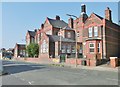
Image Listing (18 Images Found)
Images are licensed for reuse under creativecommons.org/licenses/by-sa/2.0
Image
Details
Distance
1

Sports Hall, Wallasey
As viewed from Cross Lane nature reserve. St. Hilary's church tower is in the background.
Image: © El Pollock
Taken: 22 Jul 2009
0.12 miles
3
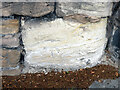
Very weathered bench mark by Breck Road, Wallasey
A very weathered cut mark on soft sandstone on the East side of Breck Road, Wallasey. It is immediately below the 'Breck Road' sign and North of the small roundabout junction. For a wider view see: Image
Image: © John S Turner
Taken: 29 Jul 2014
0.19 miles
4
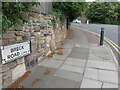
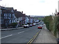
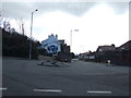
Breck Road junction with St Hilary Brow, Wallasey
The A551 follows the curve to the left from Breck Road into St Hilary Brow. There is a very weathered Ordnance Survey bench mark on the pale sandstone block immediately below the 'Breck Road' sign. See: Image
Image: © John S Turner
Taken: 29 Jul 2014
0.19 miles
5
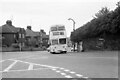
Leaning into St Hilary Brow ? 1970
Wallasey Corporation bus 12 was one of the first production batch of Leyland Atlanteans, built in 1958.
This is one of a series of views featuring buses in the 60s, 70s, and 80s. http://www.geograph.org.uk/search.php?i=137652761
Image: © Alan Murray-Rust
Taken: 24 May 1970
0.19 miles
6
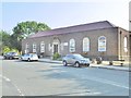
Wallasey Village Library
On St. George's Road: https://www.wirral.gov.uk/libraries-and-archives/find-library/wallasey-village-library
Image: © Mike Faherty
Taken: 4 Jul 2018
0.19 miles
8
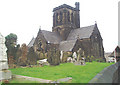
St Hilarys
This is the Parish Church of Wallasey in the Church of England Diocese of Chester. It has always been 'black' ever since I can recall.
Image: © Nigel Freeman
Taken: 20 Oct 2004
0.20 miles
10
Wallasey, primary school
St. George's Primary School, on St. George's Road: http://www.stgeorges.wirral.sch.uk/
Image: © Mike Faherty
Taken: 4 Jul 2018
0.22 miles