IMAGES TAKEN NEAR TO
Pennine Road, WALLASEY, CH44 2BJ
Introduction
This page details the photographs taken nearby to Pennine Road, CH44 2BJ by members of the Geograph project.
The Geograph project started in 2005 with the aim of publishing, organising and preserving representative images for every square kilometre of Great Britain, Ireland and the Isle of Man.

There are currently over 7.5m images from over14,400 individuals and you can help contribute to the project by visiting https://www.geograph.org.uk
Image Map
Images are licensed for reuse under creativecommons.org/licenses/by-sa/2.0
Notes
- Clicking on the map will re-center to the selected point.
- The higher the marker number, the further away the image location is from the centre of the postcode.
Image Listing (19 Images Found)
Images are licensed for reuse under creativecommons.org/licenses/by-sa/2.0
Image
Details
Distance
1
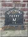
'Egremont Ferry M 1 ?' - Milepost in Wallasey Road, Wirral
This cast iron Egremont Ferry milepost stands in front of #213 Wallasey Road, near the junction with Claremount Road. Egremont Ferry dates back to the 18th century http://www.historyofwallasey.co.uk/wallasey/Wallasey_Ferries_Egremont_1761-1861/index.html but this milepost first appears on the 1935 O.S.map. See also Image
Inscription reads:-
EGREMONT
FERRY
M
1 ½
Milestone Society National ID: CH_EGF01B
Image: © John S Turner
Taken: 29 Jul 2014
0.06 miles
2
Wallasey Road and an Egremont Ferry milepost
Looking north west along Wallasey Road towards its junction with Claremount Road. There is a cast iron 'Egremont Ferry 1 1/2 M' milepost in front of #213 Wallasey Road - Image The history of Egremont Ferry dates back to the 18th century http://www.historyofwallasey.co.uk/wallasey/Wallasey_Ferries_Egremont_1761-1861/index.html , but this milepost first appears on the 1935 O.S. map.
Image: © John S Turner
Taken: 29 Jul 2014
0.06 miles
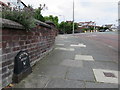
3
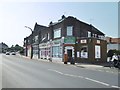
Wallasey, shopping parade
On Wallasey Road; PO & store, sandwich bar, barbers, off-licence, accountants.
Image: © Mike Faherty
Taken: 4 Jul 2018
0.08 miles
4
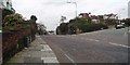
Towards Wallasey Village
Down the hill is Wallasey Village and to the right is Claremont Road with St Hilary's Church.
Image: © Nigel Freeman
Taken: Unknown
0.09 miles
5
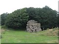
Sandstone outcrop at The Breck
Local children playing by Granny's Rock, one of the outcrops at The Breck, a recreation ground which sits on a Triassic sandstone ridge 80 feet above sea level. Local lad Alan Rouse (19 December 1951 – 10 August 1986) learnt to climb at The Breck and was the first British climber to reach the summit of K2 but sadly died on the descent.
Image: © Sue Adair
Taken: 20 Aug 2019
0.09 miles
6
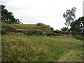
Sandstone outcrop at The Breck
The Breck, heathland adjacent to the old Wallasey Mill formerly a sandstone quarry owned by Sir John Tobin of Liscard Hall.
Image: © Sue Adair
Taken: 20 Aug 2019
0.09 miles
7
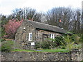
The Original Wallasey Grammar School
This cottage in Breck Road was erected as Wallasey Grammar school from 1799 replacing the original school set up in St Hilary's Parish Church which had been in existence since 1656. The school was transferred to a new premises in St George's Road in 1864 and from 1873 the school was based in Withens Lane in a building that later became a college of further education. The school moved to Birkett Lane in Leasowe in 1967 and later became known as Wallasey School. This original school building was later converted into a house. Grammar Schools were set up in the 15th century to provide free education to poor children and were generally founded by philanthropists, charitable organisations and guilds.
Image: © Sue Adair
Taken: 19 Apr 2012
0.11 miles
9
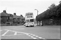
Leaning into St Hilary Brow ? 1970
Wallasey Corporation bus 12 was one of the first production batch of Leyland Atlanteans, built in 1958.
This is one of a series of views featuring buses in the 60s, 70s, and 80s. http://www.geograph.org.uk/search.php?i=137652761
Image: © Alan Murray-Rust
Taken: 24 May 1970
0.15 miles
10
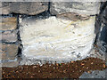
Very weathered bench mark by Breck Road, Wallasey
A very weathered cut mark on soft sandstone on the East side of Breck Road, Wallasey. It is immediately below the 'Breck Road' sign and North of the small roundabout junction. For a wider view see: Image
Image: © John S Turner
Taken: 29 Jul 2014
0.15 miles