IMAGES TAKEN NEAR TO
Westway, PRENTON, CH43 9HT
Introduction
This page details the photographs taken nearby to Westway, CH43 9HT by members of the Geograph project.
The Geograph project started in 2005 with the aim of publishing, organising and preserving representative images for every square kilometre of Great Britain, Ireland and the Isle of Man.

There are currently over 7.5m images from over14,400 individuals and you can help contribute to the project by visiting https://www.geograph.org.uk
Image Map (Loading...)


Getting Data...Please wait
Leaflet Map data © OpenStreetMap
Images are licensed for reuse under creativecommons.org/licenses/by-sa/2.0
Notes
- Clicking on the map will re-center to the selected point.
- The higher the marker number, the further away the image location is from the centre of the postcode.
Image Listing (3 Images Found)
Images are licensed for reuse under creativecommons.org/licenses/by-sa/2.0
Image
Details
Distance
3
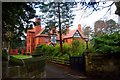
Rathmore
One of the few remaining large Victorian houses in Noctorum Lane, built for Liverpool shipowners and businessmen in a style succinctly described by Pevsner's Birkonian colleague, Edward Hubbard, as "very large and very red". Grade II listed. http://www.britishlistedbuildings.co.uk/en-389263-rathmore-birkenhead
Image: © Tiger
Taken: 25 Dec 2008
0.21 miles