IMAGES TAKEN NEAR TO
Noctorum Avenue, PRENTON, CH43 9EB
Introduction
This page details the photographs taken nearby to Noctorum Avenue, CH43 9EB by members of the Geograph project.
The Geograph project started in 2005 with the aim of publishing, organising and preserving representative images for every square kilometre of Great Britain, Ireland and the Isle of Man.

There are currently over 7.5m images from over14,400 individuals and you can help contribute to the project by visiting https://www.geograph.org.uk
Image Map (Loading...)


Getting Data...Please wait
Leaflet Map data © OpenStreetMap
Images are licensed for reuse under creativecommons.org/licenses/by-sa/2.0
Notes
- Clicking on the map will re-center to the selected point.
- The higher the marker number, the further away the image location is from the centre of the postcode.
Image Listing (7 Images Found)
Images are licensed for reuse under creativecommons.org/licenses/by-sa/2.0
Image
Details
Distance
1
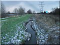
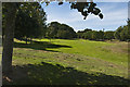
Storm clouds brew over the River Fender
Image: © David Jones
Taken: 20 Dec 2009
0.14 miles
4
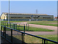
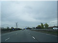
Woodchurch Sportsbarn and Track
What's the name of this place again - oh yes, you can just about see it on the side of the building! It's actually at the back of the Woodchurch Leisure Centre in Wirral. On the right hand side of this photo, there is the M53 motorway.
Image: © Peter Craine
Taken: 6 Jul 2006
0.16 miles
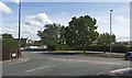
7
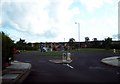
Roundabout, Noctorum Way
Viewed from Wethersfield Road, looking towards Stubbs Lane.
Image: © El Pollock
Taken: 21 Jul 2009
0.24 miles