IMAGES TAKEN NEAR TO
Torwood, PRENTON, CH43 7XP
Introduction
This page details the photographs taken nearby to Torwood, CH43 7XP by members of the Geograph project.
The Geograph project started in 2005 with the aim of publishing, organising and preserving representative images for every square kilometre of Great Britain, Ireland and the Isle of Man.

There are currently over 7.5m images from over14,400 individuals and you can help contribute to the project by visiting https://www.geograph.org.uk
Image Map (Loading...)


Getting Data...Please wait
Leaflet Map data © OpenStreetMap
Images are licensed for reuse under creativecommons.org/licenses/by-sa/2.0
Notes
- Clicking on the map will re-center to the selected point.
- The higher the marker number, the further away the image location is from the centre of the postcode.
Image Listing (21 Images Found)
Images are licensed for reuse under creativecommons.org/licenses/by-sa/2.0
Image
Details
Distance
1
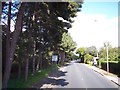
Pine trees line Upton Road near Bidston
Image: © Raymond Knapman
Taken: 30 Aug 2012
0.13 miles
2
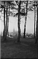
On Bidston Hill ? Boxing Day 1968 ? 1
View from King George's Way looking through the pines towards Flaybrick Cemetery.
Image: © Alan Murray-Rust
Taken: 26 Dec 1968
0.14 miles
3
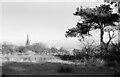
On Bidston Hill ? Boxing Day 1968 ? 2
View from King George's Way looking towards Flaybrick Cemetery. At this date the chapels were still in use and the fine spire intact. Today the spire has been truncated and the chapels are ruinous, although Listed Grade II.
Image: © Alan Murray-Rust
Taken: 26 Dec 1968
0.18 miles
6

On Bidston Hill ? Boxing Day 1968 ? 3
Path towards the windmill. This is largely the naked sandstone, with puddles between which on this day were heavily frozen.
Image: © Alan Murray-Rust
Taken: 26 Dec 1968
0.19 miles
7
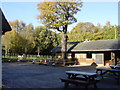
Car park - Bidston Nature Reserve
This is the car park that provides access to the paths to Bidston Windmill. I took this view on returning from the mill on a very murky Sunday morning.
Image: © Chris Allen
Taken: 15 Apr 2018
0.20 miles
9
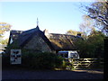
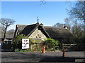
Tam O'Shanter Cottage, Bidston Hill
Tam O'Shanter Cottage, which was probably built about 300 years ago by a heath squatter, is situated at the edge of Bidston Hill near to the rear entrance to Flaybrick Cemetery.
As far as we know it had no particular claim to fame until 1837 when Richard Lea the occupier at that time embellished the building with a carved stone slab depicting Burns poem "Tam O'Shanter" in which Tam pursued by witches sought to reach the bridge in the belief that the witches would not dare to cross running water. Tam indeed escaped but his mare poor Maggie lost her tail.
In Auld Lang Syne, by Harry B. Neilson, printed in 1935, mention is made that the date 1837 can be seen on a stone garden wall of the cottage. It is stated that Richard Leay cut the date on the wall and carved the Tam O'Shanter stone and also the weather vane with its animals heads, lion, dog etc. It is said he made them in his spare time to decorate his cottage. Part of the cottage will be seen in the foreground to be roofed with thick, stone, flags, which in past times was a common method of covering buildings in Bidston, where stone was plentiful.The list of farms which were on the Bidston Hill heathland in the year 1840 includes the Tam 0'Shanter farm and tells us that the size of the farm was 6 acres. We know that in 1841 Richard Lea was a master stonemason. At that time, there was a great deal of building going on in Birkenhead. Hamilton Square, the Town Hall, Cammell Lairds, Bidston Observatory, Bidston Lighthouse and many churches were being built in the 19th century and there would have been plenty of work for Richard Lea in Birkenhead. So we might imagine Richard Lea shaping stone for these buildings, as well as working on the Tam O'Shanter farm, looking after hens, pigs, cows and growing crops. Thus the cottage became known as Tam O'Shanter Cottage and became a favourite subject for artists and visitors alike. (Taken from http://www.tamoshanterfarm.org.uk/history.htm)
Image: © Sue Adair
Taken: 13 Nov 2005
0.21 miles
10
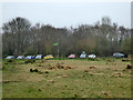
Tam O'Shanter Urban Farm
Tam O'Shanter Cottage, which was probably built about 300 years ago by a heath squatter, is situated at the edge of Bidston Hill. Sadly most of the building was destroyed by fire in 1954 and the Council considered demolishing it, but it was saved by public protest. Following a further fire in 1975 and subsequent vandalism, the council decided to demolish the building completely. The Birkenhead History Society stepped in to try and save the building because it represented a period before the area became industrialised. In June 1975 they were given 30 days to submit their suggestions and in August they won permission from Wirral Borough Council for the cottage to be rebuilt and restored to its former glory but rather than return the cottage to residential use the Society felt that the townspeople would be better served by having a field study centre which could be used by local school children. A Charitable Trust was formed in conjunction with Wirral District Council and a grant was obtained from the Manpower Services Commission under the Job Creation Programme.
The cottage was open for schools from May 1977 and in 1986 a voluntary organisation called the Wirral Urban Farm Association together with the Tam O'Shanter Cottage Trust began to develop the 4 acres around the cottage as a city farm. The construction of farm buildings, paths and fencing was soon followed by a collection of farm animals. The aim of the new trust was to make this varied collection of farm animals accessible to many people, especially children. By fundraising, grants, donations, support from the Metropolitan Borough of Wirral the farm is able to maintain itself without an admission charge while being open every day (9.30am - 4.30pm).
Partly taken from http://www.tamoshanterfarm.org.uk/history.htm
Image: © Sue Adair
Taken: 13 Nov 2005
0.21 miles