
IMAGES TAKEN NEAR TO
Sandstone Rise, PRENTON, CH43 6WD
Introduction
This page details the photographs taken nearby to Sandstone Rise, CH43 6WD by members of the Geograph project.
The Geograph project started in 2005 with the aim of publishing, organising and preserving representative images for every square kilometre of Great Britain, Ireland and the Isle of Man.

There are currently over 7.5m images from over14,400 individuals and you can help contribute to the project by visiting https://www.geograph.org.uk
Image Map
Images are licensed for reuse under creativecommons.org/licenses/by-sa/2.0
Notes
- Clicking on the map will re-center to the selected point.
- The higher the marker number, the further away the image location is from the centre of the postcode.
Image Listing (26 Images Found)
Images are licensed for reuse under creativecommons.org/licenses/by-sa/2.0
Image
Details
Distance
1
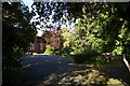
Highfield School, Bidston Road
The local paper claims that this school (an independent from kindergarten age to GSCE levels) shut its doors in July 2007. This would be a shame if true.
Image: © Fractal Angel
Taken: 16 Aug 2007
0.10 miles
2
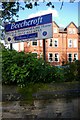
Beechcroft Residential Home
This area could fairly be described as "Nursing Home Central". Many large Victorian houses (built for rich merchants and importers) are now too large for modern families and have been converted into nursing homes. Others have been knocked down and the land used to build sheltered flats for elderly people less in need of full-time care.
Image: © Fractal Angel
Taken: 16 Aug 2007
0.10 miles
3

Victorian postbox, Bidston Road
The undoubtedly much more modern box attached to this nice postbox appears to have weathered much less well!
Image: © Fractal Angel
Taken: 16 Aug 2007
0.11 miles
6
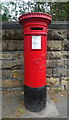
Victorian postbox on Bidston Road, Birkenhead
Postbox No. CH43 160.
Image: © JThomas
Taken: 25 May 2019
0.15 miles
7
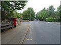
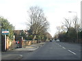
Bidston Road, Birkenhead
Showing position of Postbox No. CH43 160.
Image: © JThomas
Taken: 25 May 2019
0.16 miles
8
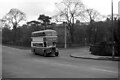
Birkenhead Transport bus 252 on Tollemache Road ? 1967
The driver would have his foot hard on the floor to tackle the steep section of Tollemache Road ahead (approx 1 in 10). This was my local bus service and usually the bus would have slowed down enough on the gradient to enable one to drop off at the end of my road rather than being carried another 100 yards or so to the official stop.
Behind the bus can be seen the rear of St Aidans Terrace, a fine classical terrace from a relatively early period of the development of the town (c.1850), Listed Grade II.
The bus is one of the wartime (1944) Guy Arab II buses which were given new Massey bodies in 1953 and would remain in service until 1969 after 25 years' service.
This is one of a series of views featuring buses in the 60s, 70s, and 80s.
http://www.geograph.org.uk/search.php?i=2114547&displayclass=slide
Image: © Alan Murray-Rust
Taken: 18 Feb 1967
0.16 miles
9
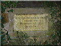
Stone plaque marking the site of St Aidan's College
St Aidan's Theological College was a large brick building built in the Tudor style, which taught Anglican students of theology. It is now demolished, and replaced by housing on the site. This plaque in one of the original walls surrounding the site is located approximately 100 metres north of the original building.
Image: © Robin Lucas
Taken: 28 Jan 2011
0.16 miles
10
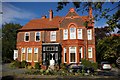
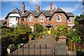
Fine old house alongside Bidston Road
A typical example of the type of brick used in the area.
Image: © Fractal Angel
Taken: 16 Aug 2007
0.18 miles