IMAGES TAKEN NEAR TO
Parrs Road, PRENTON, CH43 5TX
Introduction
This page details the photographs taken nearby to Parrs Road, CH43 5TX by members of the Geograph project.
The Geograph project started in 2005 with the aim of publishing, organising and preserving representative images for every square kilometre of Great Britain, Ireland and the Isle of Man.

There are currently over 7.5m images from over14,400 individuals and you can help contribute to the project by visiting https://www.geograph.org.uk
Image Map
Images are licensed for reuse under creativecommons.org/licenses/by-sa/2.0
Notes
- Clicking on the map will re-center to the selected point.
- The higher the marker number, the further away the image location is from the centre of the postcode.
Image Listing (5 Images Found)
Images are licensed for reuse under creativecommons.org/licenses/by-sa/2.0
Image
Details
Distance
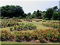
2
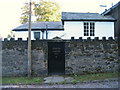
Stourton Lodge, 8 South Bank, Oxton
The photo was actually taken in Arno Road - South Bank is a narrow track.
Image: © Peter Craine
Taken: 20 Aug 2006
0.15 miles
3

Providence Particular Baptist Chapel
An unassuming modern building in Storeton Road, Oxton
Image: © Tiger
Taken: 15 Oct 2010
0.19 miles
4
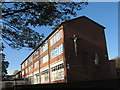
St Joseph's Catholic Primary School
This school was built on Woodchurch Road, Oxton on the site of ‘Heathley', the home of Mr Joseph Bell Topham, the main benefactor of St Joseph's Parish. He was descended from one of the oldest and best known Catholic families in Cheshire and offered the private chapel at his house for Mass prior to the building of the first church. St Joseph's foundation stone was laid in 1899, the land at the junction of Willow Bank and North Road having been purchased and then donated by him to the parish of St Joseph’s for the building of a church and presbytery.
Image: © Sue Adair
Taken: 4 Nov 2012
0.23 miles