IMAGES TAKEN NEAR TO
Cearns Road, PRENTON, CH43 2JP
Introduction
This page details the photographs taken nearby to Cearns Road, CH43 2JP by members of the Geograph project.
The Geograph project started in 2005 with the aim of publishing, organising and preserving representative images for every square kilometre of Great Britain, Ireland and the Isle of Man.

There are currently over 7.5m images from over14,400 individuals and you can help contribute to the project by visiting https://www.geograph.org.uk
Image Map (Loading...)


Getting Data...Please wait
Leaflet Map data © OpenStreetMap
Images are licensed for reuse under creativecommons.org/licenses/by-sa/2.0
Notes
- Clicking on the map will re-center to the selected point.
- The higher the marker number, the further away the image location is from the centre of the postcode.
Image Listing (31 Images Found)
Images are licensed for reuse under creativecommons.org/licenses/by-sa/2.0
Image
Details
Distance
1

Penfold Victorian postbox, Alton Road
The local vandals have made their own additions to this fine rare postbox. It is also missing its top.
Image: © Fractal Angel
Taken: 17 Aug 2007
0.05 miles
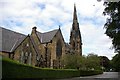
3
Trinity with Palm Grove Church, Beresford Road, Oxton
Image: © El Pollock
Taken: 19 Jul 2009
0.08 miles
5

Birkenhead School campus
The old gymnasium.
Image: © Robin Lucas
Taken: 16 Apr 2016
0.18 miles
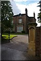
6
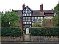
59 Shrewsbury Road, Birkenhead
By George Smith, c1884. Grade II listed.
Image: © Stephen Richards
Taken: 21 Aug 2014
0.18 miles
7

Birkenhead School campus
The school campus has the sports field at the centre. This view shows the cricket pavilion to the left, and to the right of it the original “big school” (as it is known to pupils) which dates back to 1871. To the right of that building is the school chapel which was opened in 1883.
Image: © Robin Lucas
Taken: 16 Apr 2016
0.18 miles
8
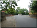
Gerald Road, Birkenhead
Looking north east.
Image: © JThomas
Taken: 25 May 2019
0.18 miles
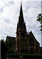
9
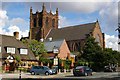
St Saviour's church, Oxton
Formerly an Anglo-Catholic church (prior to about 1979) this church has slipped down the candle rather and is now fairly middle-of-the-road.
Image: © Fractal Angel
Taken: 16 Aug 2007
0.19 miles
10
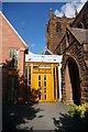
St Saviour's church
Tower and Parish Centre (opened 2006). There are various meeting rooms in the Parish Centre, as well as offices and a refreshments area.
Image: © Fractal Angel
Taken: 16 Aug 2007
0.19 miles