IMAGES TAKEN NEAR TO
Grosvenor Road, PRENTON, CH43 1TJ
Introduction
This page details the photographs taken nearby to Grosvenor Road, CH43 1TJ by members of the Geograph project.
The Geograph project started in 2005 with the aim of publishing, organising and preserving representative images for every square kilometre of Great Britain, Ireland and the Isle of Man.

There are currently over 7.5m images from over14,400 individuals and you can help contribute to the project by visiting https://www.geograph.org.uk
Image Map
Images are licensed for reuse under creativecommons.org/licenses/by-sa/2.0
Notes
- Clicking on the map will re-center to the selected point.
- The higher the marker number, the further away the image location is from the centre of the postcode.
Image Listing (15 Images Found)
Images are licensed for reuse under creativecommons.org/licenses/by-sa/2.0
Image
Details
Distance
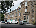
1
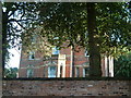
Grosvenor Road, Birkenhead
This house was built in 1866 and the date is set in the brickwork above the central ground floor window.
Image: © Robin Lucas
Taken: 20 Aug 2006
0.06 miles
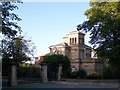
2
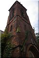
Tower of former Catholic Apostolic Church
This Grade II Listed Building at the junction of Park Road South and Merton Place was opened in 1875 as a Catholic Apostolic Church. It later became the Church of Christ and more recently the Park Christian Centre. The building was gutted by fire in June 2009 leaving only the walls and tower - Image
Image: © Fractal Angel
Taken: 17 Aug 2007
0.12 miles
3
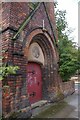
Porch of former Catholic Apostolic Church
This Grade II Listed Building at the junction of Park Road South and Merton Place was opened in 1875 as a Catholic Apostolic Church. It later became the Church of Christ and more recently the Park Christian Centre. The building was gutted by fire in June 2009 leaving only the walls and tower - Image
Image: © Fractal Angel
Taken: 17 Aug 2007
0.12 miles
4
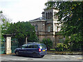
Italian Lodge, Park Road South, Birkenhead
A single lodge at the south end of Birkenhead Park, probably the pick of the bunch. By John Robertson and Lewis Hornblower, c1845. Grade II listed.
Image: © Stephen Richards
Taken: 22 Aug 2014
0.16 miles
5
Cannon Hill, Park Road West, Birkenhead
An upmarket terrace of the late 1850s or early 1860s, among the best of the planned developments around the perimeter of Birkenhead Park. Grade II listed.
Image: © Stephen Richards
Taken: 22 Aug 2014
0.17 miles
6
Birkenhead Park Entrance House, Park Road South
Situated at the entrance to Birkenhead Park, on Park Road South. Park High School is visible behind.
Image: © El Pollock
Taken: 20 Jul 2009
0.17 miles
7
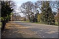
Park Drive, Birkenhead Park
This is the perimeter road of Birkenhead Park. The road can be closed to traffic, due to cycle racing, on Sundays, occasionally.
Image: © El Pollock
Taken: 24 Mar 2012
0.18 miles
8
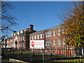
University Academy of Birkenhead
The University Academy of Birkenhead in Park Road South was formed following the merger of Park High School and Rock Ferry High School.
Image: © Sue Adair
Taken: 4 Nov 2012
0.19 miles
9
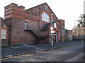
Grange Road West Sports Centre
A local sports centre on the outskirts of Birkenhead. The building was originally a territorial army training centre, but was converted to a sports centre in 1969 when the council took ownership. I had to make a small edit on the signpost to remove some bright colours.
Image: © David Quinn
Taken: 18 Jan 2009
0.19 miles
10
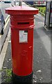
Victorian postbox
Spotted on Park Road South.
Image: © Fractal Angel
Taken: 17 Aug 2007
0.19 miles