IMAGES TAKEN NEAR TO
Gorsefield Road, BIRKENHEAD, CH42 9NS
Introduction
This page details the photographs taken nearby to Gorsefield Road, CH42 9NS by members of the Geograph project.
The Geograph project started in 2005 with the aim of publishing, organising and preserving representative images for every square kilometre of Great Britain, Ireland and the Isle of Man.

There are currently over 7.5m images from over14,400 individuals and you can help contribute to the project by visiting https://www.geograph.org.uk
Image Map
Images are licensed for reuse under creativecommons.org/licenses/by-sa/2.0
Notes
- Clicking on the map will re-center to the selected point.
- The higher the marker number, the further away the image location is from the centre of the postcode.
Image Listing (15 Images Found)
Images are licensed for reuse under creativecommons.org/licenses/by-sa/2.0
Image
Details
Distance
1
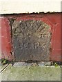
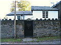
Old Milestone by 135 Gorsefield Road, Devonshire Park, Birkenhead Parish
By the UC road, in parish of Birkenhead (Wirral District), Gorsefield Road, Devonshire Park, by No 135 built into low wall.
Inscription reads:- : WOODSIDE / FERRY / 2 :
Surveyed
Milestone Society National ID: CH_WSFC02
Image: © Milestone Society
Taken: Unknown
0.08 miles
3
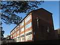
St Joseph's Catholic Primary School
This school was built on Woodchurch Road, Oxton on the site of ‘Heathley', the home of Mr Joseph Bell Topham, the main benefactor of St Joseph's Parish. He was descended from one of the oldest and best known Catholic families in Cheshire and offered the private chapel at his house for Mass prior to the building of the first church. St Joseph's foundation stone was laid in 1899, the land at the junction of Willow Bank and North Road having been purchased and then donated by him to the parish of St Joseph’s for the building of a church and presbytery.
Image: © Sue Adair
Taken: 4 Nov 2012
0.12 miles
4
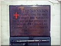
Commemorative Plaque
Inside Singleton 33kV substation is this plaque: This sub-station completing the high tension ring main round the borough was opened by couincillor J W Collins ESQ. Chairman of the electricity committee September 4th 1924
Image: © Ed Lloyd-Hughes
Taken: 6 May 2011
0.15 miles
5
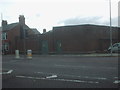
Singleton road 33Kv Primary substation
Anonymous brick building housing the sparks for the borough. Inside a plaque commemorating the area electrification in 1924.
Image: © Ed Lloyd-Hughes
Taken: 6 May 2011
0.15 miles
6
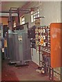
Singleton Rd 11Kv transformer and LV board
The 11 thousand volt transformer to the left, the big grey finned thing, and the fuses board to the right. When the light around Singleton avenue go out watch out for the local engineers rushing in to sort things out. It is worth pointing out that it is pretty easy to get killed in these places as the conductors are not shielded. Touch one and flash bang, gone.
Image: © Ed Lloyd-Hughes
Taken: 6 May 2011
0.15 miles
7
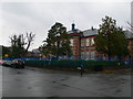
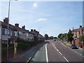
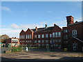
Devonshire Park Primary School, Prenton
The school was opened as Temple Road Council School in January 1914. It was redesignated a Central School in August, 1922 - one of six intended to take in all pupils from local Elementary schools at the age of eleven. In 1983 it lost its 11+ pupils and became Devonshire Park Primary School.
Image: © Eirian Evans
Taken: 17 Nov 2010
0.17 miles
8
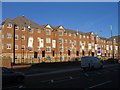
Eaton Place apartments, Birkenhead
These apartments, on Borough Road, have replaced the old technical college AKA Wirral Metropolitan College. The building was abandoned, left to decay, and the whole site has been demolished and rebuilt over the past year. Wirral Metropolitan College still exists, but in locations in Conway Park and Twelve Quays.
Image: © Peter Craine
Taken: 3 Nov 2006
0.17 miles
10
Stourton Lodge, 8 South Bank, Oxton
The photo was actually taken in Arno Road - South Bank is a narrow track.
Image: © Peter Craine
Taken: 20 Aug 2006
0.20 miles