IMAGES TAKEN NEAR TO
Mount Road, BIRKENHEAD, CH42 8NJ
Introduction
This page details the photographs taken nearby to Mount Road, CH42 8NJ by members of the Geograph project.
The Geograph project started in 2005 with the aim of publishing, organising and preserving representative images for every square kilometre of Great Britain, Ireland and the Isle of Man.

There are currently over 7.5m images from over14,400 individuals and you can help contribute to the project by visiting https://www.geograph.org.uk
Image Map
Images are licensed for reuse under creativecommons.org/licenses/by-sa/2.0
Notes
- Clicking on the map will re-center to the selected point.
- The higher the marker number, the further away the image location is from the centre of the postcode.
Image Listing (10 Images Found)
Images are licensed for reuse under creativecommons.org/licenses/by-sa/2.0
Image
Details
Distance
1
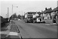
Borough Road, Birkenhead ? 1972
Classic inter-war semi-detached housing development along what was a traditional highway between Birkenhead and Higher Bebington, originally named Happy Valley Road. The elegant cast iron lighting columns were a typical feature of Birkenhead.
The bus is Birkenhead Corporation 360, a Guy Arab IV with Massey bodywork running out of service to take up service somewhere in the Bebington area.
This is one of a series of views featuring buses in the 60s, 70s, and 80s. http://www.geograph.org.uk/search.php?i=137652761
Image: © Alan Murray-Rust
Taken: 29 Mar 1972
0.07 miles
5
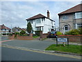
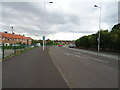
The Wiend near Egerton Park joins Bedford Drive
Image: © Raymond Knapman
Taken: 4 Apr 2014
0.15 miles
6

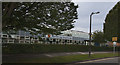
Prenton Park 1986, Birkenhead
This was taken before the Hillsborough disaster, and the requirement for all-seater stadia. The area looks a lot more presentable now, but the stadium tends to obliterate the skyline. Also kids can no longer use the paths by the allotments for scrambling on push bikes. The Harris allotments are still there though.
Image: © Peter Craine
Taken: Unknown
0.15 miles
8
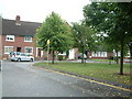
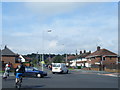
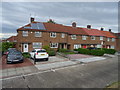
Pennine Road, Prenton
Pennine Road, on the Mount Estate. House numbers 19-27 visible in whole or in part. These houses were built in the early 1950's
Image: © Robin Lucas
Taken: 20 Aug 2006
0.19 miles