IMAGES TAKEN NEAR TO
Burrell Road, BIRKENHEAD, CH42 8NH
Introduction
This page details the photographs taken nearby to Burrell Road, CH42 8NH by members of the Geograph project.
The Geograph project started in 2005 with the aim of publishing, organising and preserving representative images for every square kilometre of Great Britain, Ireland and the Isle of Man.

There are currently over 7.5m images from over14,400 individuals and you can help contribute to the project by visiting https://www.geograph.org.uk
Image Map
Images are licensed for reuse under creativecommons.org/licenses/by-sa/2.0
Notes
- Clicking on the map will re-center to the selected point.
- The higher the marker number, the further away the image location is from the centre of the postcode.
Image Listing (11 Images Found)
Images are licensed for reuse under creativecommons.org/licenses/by-sa/2.0
Image
Details
Distance
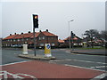
1
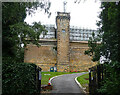
Reservoir, Tower Road, Birkenhead
Prenton Reservoir, operated by United Utilities, is tucked away in leafy suburbia. The reservoir itself is covered; this structure may be a water tower.
Image: © Stephen Richards
Taken: 21 Aug 2014
0.10 miles
2
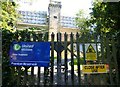
Prenton Reservoir
This covered reservoir in a castellated architectural style (perhaps more accurately described as a water tower) stands at the corner of Reservoir Road and Tower Road and is operated by United Utilities.
Image: © Tiger
Taken: 12 Jun 2010
0.11 miles
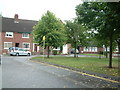
3
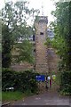
Prenton Hill Water Tower
Prenton Hill, 81 metres, a P43 hill, in locked water compound with disused water tower at junction of Tower Road and Reservoir Road.
Image: © Rude Health
Taken: 8 Aug 2012
0.12 miles
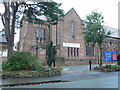
7
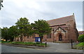
St Stephen's Church, Prenton
On Prenton Lane.
Image: © JThomas
Taken: 15 Jun 2019
0.24 miles
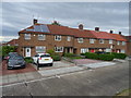
8
Pennine Road, Prenton
Pennine Road, on the Mount Estate. House numbers 19-27 visible in whole or in part. These houses were built in the early 1950's
Image: © Robin Lucas
Taken: 20 Aug 2006
0.24 miles
9
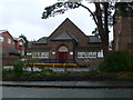
St Stephen's Church Hall
On Prenton Lane.
Image: © Eirian Evans
Taken: 17 Nov 2010
0.24 miles
10
St Stephen's Church, Prenton
On Prenton Lane.
Image: © Eirian Evans
Taken: 17 Nov 2010
0.25 miles