IMAGES TAKEN NEAR TO
Waterpark Road, BIRKENHEAD, CH42 8LS
Introduction
This page details the photographs taken nearby to Waterpark Road, CH42 8LS by members of the Geograph project.
The Geograph project started in 2005 with the aim of publishing, organising and preserving representative images for every square kilometre of Great Britain, Ireland and the Isle of Man.

There are currently over 7.5m images from over14,400 individuals and you can help contribute to the project by visiting https://www.geograph.org.uk
Image Map
Images are licensed for reuse under creativecommons.org/licenses/by-sa/2.0
Notes
- Clicking on the map will re-center to the selected point.
- The higher the marker number, the further away the image location is from the centre of the postcode.
Image Listing (10 Images Found)
Images are licensed for reuse under creativecommons.org/licenses/by-sa/2.0
Image
Details
Distance
1
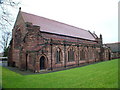
Saint Stephen's Church, Prenton
This is a beautiful red sandstone building. Note there is no tower or spire, when it was built in the late 19th century, the parish decided to have a curate instead.
Image: © Charlie Jordan
Taken: 31 Dec 2005
0.04 miles
2
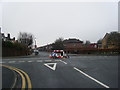
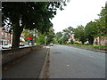
Waterpark Road/Glenavon Road temporary mini-roundabout.
Image: © Colin Pyle
Taken: 22 Jan 2010
0.10 miles
3
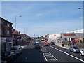
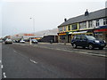
Shopping centre on Woodchurch Road Prenton
Image: © Raymond Knapman
Taken: 6 Sep 2012
0.18 miles
4
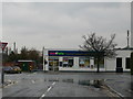
Veterinary Surgery on Woodchurch Road, Prenton
Image: © Eirian Evans
Taken: 17 Nov 2010
0.18 miles
6

A Wirral Enigma
The signs for the Keyboard Repair Centre on Woodchurch Road, Prenton quote the first bar and a half of Elgar's Enigma Variations.
Image: © Tiger
Taken: 31 Mar 2011
0.21 miles
8
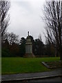
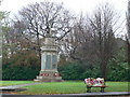
Prenton War Memorial
At the junction of Osmaston Road and Prenton Lane.
Image: © Eirian Evans
Taken: 17 Nov 2010
0.24 miles
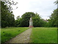
10
Prenton War Memorial
On the junction of Prenton Hall Road and Osmaston Road.
Image: © Eirian Evans
Taken: 17 Nov 2010
0.24 miles