IMAGES TAKEN NEAR TO
Prenton Lane, BIRKENHEAD, CH42 8LA
Introduction
This page details the photographs taken nearby to Prenton Lane, CH42 8LA by members of the Geograph project.
The Geograph project started in 2005 with the aim of publishing, organising and preserving representative images for every square kilometre of Great Britain, Ireland and the Isle of Man.

There are currently over 7.5m images from over14,400 individuals and you can help contribute to the project by visiting https://www.geograph.org.uk
Image Map
Images are licensed for reuse under creativecommons.org/licenses/by-sa/2.0
Notes
- Clicking on the map will re-center to the selected point.
- The higher the marker number, the further away the image location is from the centre of the postcode.
Image Listing (19 Images Found)
Images are licensed for reuse under creativecommons.org/licenses/by-sa/2.0
Image
Details
Distance
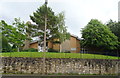
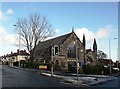
1
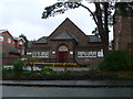
St Stephen's Church Hall
On Prenton Lane.
Image: © Eirian Evans
Taken: 17 Nov 2010
0.05 miles
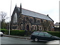
3
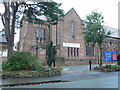
St Stephen's Church, Prenton
On Prenton Lane.
Image: © Eirian Evans
Taken: 17 Nov 2010
0.07 miles
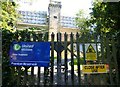
4
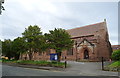
St Stephen's Church, Prenton
On Prenton Lane.
Image: © JThomas
Taken: 15 Jun 2019
0.07 miles
5
Church of Jesus Christ of Latter Day Saints, Prenton
Image: © JThomas
Taken: 15 Jun 2019
0.11 miles
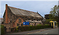
6
Prenton United Reformed Church
The site of the church is at the junction of Storeton Road and Prenton Road West, on the border of what was the County Borough of Birkenhead at the end of the 19th century. In 1901 this formed the terminus of an electric tram route from the centre of town. The original church is now the church hall Image
Image: © Eirian Evans
Taken: 17 Nov 2010
0.15 miles
7
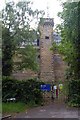
Prenton Reservoir
This covered reservoir in a castellated architectural style (perhaps more accurately described as a water tower) stands at the corner of Reservoir Road and Tower Road and is operated by United Utilities.
Image: © Tiger
Taken: 12 Jun 2010
0.15 miles
10
Prenton Hill Water Tower
Prenton Hill, 81 metres, a P43 hill, in locked water compound with disused water tower at junction of Tower Road and Reservoir Road.
Image: © Rude Health
Taken: 8 Aug 2012
0.16 miles