IMAGES TAKEN NEAR TO
Greenbank Road, BIRKENHEAD, CH42 7JT
Introduction
This page details the photographs taken nearby to Greenbank Road, CH42 7JT by members of the Geograph project.
The Geograph project started in 2005 with the aim of publishing, organising and preserving representative images for every square kilometre of Great Britain, Ireland and the Isle of Man.

There are currently over 7.5m images from over14,400 individuals and you can help contribute to the project by visiting https://www.geograph.org.uk
Image Map
Images are licensed for reuse under creativecommons.org/licenses/by-sa/2.0
Notes
- Clicking on the map will re-center to the selected point.
- The higher the marker number, the further away the image location is from the centre of the postcode.
Image Listing (15 Images Found)
Images are licensed for reuse under creativecommons.org/licenses/by-sa/2.0
Image
Details
Distance
1
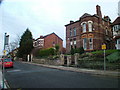
Rocky Bank Road
Typical Victorian houses found in this area of Tranmere, also known as Devonshire Park.
Image: © Charlie Jordan
Taken: 31 Dec 2005
0.11 miles
2
Terraced cottages on Prenton Road East
Image: © Eirian Evans
Taken: 17 Nov 2010
0.11 miles
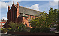
5
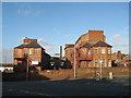
St Catherine's Community Hospital, Higher Tranmere
A new Birkenhead Union workhouse was built in 1861-3, the architect was Thomas Layland of Liverpool. It could accommodate about 500 inmates and opened its doors on 4th January, 1864. The original workhouse hospital was built at the south of the site in 1866. In 1911-13 this was replaced by the two new hospital pavilions which are shown in the photograph. The workhouse later became Birkenhead Municipal Hospital but is now known as St Catherine's Community Hospital.
Image: © Sue Adair
Taken: 17 Jan 2007
0.19 miles
6
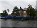
Devonshire Park Primary School, Prenton
The school was opened as Temple Road Council School in January 1914. It was redesignated a Central School in August, 1922 - one of six intended to take in all pupils from local Elementary schools at the age of eleven. In 1983 it lost its 11+ pupils and became Devonshire Park Primary School.
Image: © Eirian Evans
Taken: 17 Nov 2010
0.19 miles
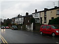
7
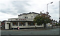
The Sportsman, Prenton Road East, Birkenhead
Deco pub.
Image: © Stephen Richards
Taken: 21 Aug 2014
0.19 miles
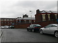
9
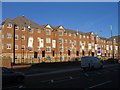
Eaton Place apartments, Birkenhead
These apartments, on Borough Road, have replaced the old technical college AKA Wirral Metropolitan College. The building was abandoned, left to decay, and the whole site has been demolished and rebuilt over the past year. Wirral Metropolitan College still exists, but in locations in Conway Park and Twelve Quays.
Image: © Peter Craine
Taken: 3 Nov 2006
0.22 miles
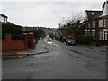
10

Church Road, Higher Tranmere
Church Road, Higher Tranmere with St Catherine's Church in the background.
Image: © Sue Adair
Taken: 10 Jan 2007
0.23 miles