IMAGES TAKEN NEAR TO
Tranmere Court, Church Road, BIRKENHEAD, CH42 5AB
Introduction
This page details the photographs taken nearby to Tranmere Court, Church Road, CH42 5AB by members of the Geograph project.
The Geograph project started in 2005 with the aim of publishing, organising and preserving representative images for every square kilometre of Great Britain, Ireland and the Isle of Man.

There are currently over 7.5m images from over14,400 individuals and you can help contribute to the project by visiting https://www.geograph.org.uk
Image Map
Images are licensed for reuse under creativecommons.org/licenses/by-sa/2.0
Notes
- Clicking on the map will re-center to the selected point.
- The higher the marker number, the further away the image location is from the centre of the postcode.
Image Listing (32 Images Found)
Images are licensed for reuse under creativecommons.org/licenses/by-sa/2.0
Image
Details
Distance
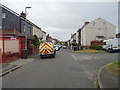
1

Church Road, Birkenhead
Looking south west on the B5148.
Image: © JThomas
Taken: 25 May 2019
0.06 miles
3
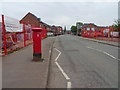
B5148, Birkenhead
Showing position of Postbox No. CH42 85.
Image: © JThomas
Taken: 25 May 2019
0.10 miles
4
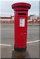
George V postbox on the B5148, Birkenhead
Postbox No. CH42 85.
Image: © JThomas
Taken: 25 May 2019
0.11 miles
5
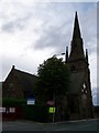
St. Catherine's Church, Tranmere
Situated on Church Road, opposite Church Terrace. St. Catherine's Hospital is behind the church, the entrance for the hospital being on Derby Road.
Image: © El Pollock
Taken: 22 Jul 2009
0.11 miles

8
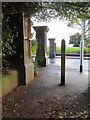
Gateposts and a bench mark in Mersey Park, Tranmere
Looking towards some of the gateposts in Agnes Road, Mersey park from the alley between Allerton Road and Agnes Road. There is an Ordnance Survey bench mark on the low wall on the left - Image
Image: © John S Turner
Taken: 8 Dec 2018
0.14 miles
9
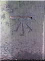
Bench mark off Agnes Road, Tranmere
This Ordnance Survey bench mark is in a narrow alley between Agnes Road and Allerton Road, off Mersey Park, Tranmere. See also Image
Image: © John S Turner
Taken: 8 Dec 2018
0.14 miles
10
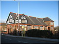
St Catherine's Institute
St Catherine's Institute on Church Road, built 1892.
Image: © Sue Adair
Taken: 17 Jan 2007
0.15 miles