IMAGES TAKEN NEAR TO
Hawkhurst Drive, BIRKENHEAD, CH42 2AR
Introduction
This page details the photographs taken nearby to Hawkhurst Drive, CH42 2AR by members of the Geograph project.
The Geograph project started in 2005 with the aim of publishing, organising and preserving representative images for every square kilometre of Great Britain, Ireland and the Isle of Man.

There are currently over 7.5m images from over14,400 individuals and you can help contribute to the project by visiting https://www.geograph.org.uk
Image Map
Images are licensed for reuse under creativecommons.org/licenses/by-sa/2.0
Notes
- Clicking on the map will re-center to the selected point.
- The higher the marker number, the further away the image location is from the centre of the postcode.
Image Listing (70 Images Found)
Images are licensed for reuse under creativecommons.org/licenses/by-sa/2.0
Image
Details
Distance
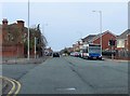
2
Demolition site in Rock Lane West
This demolition site is on the junction of Rock Lane West and New Chester Road.
Image: © John S Turner
Taken: 21 Mar 2016
0.13 miles
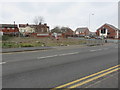
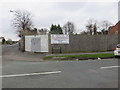
3
Development site in Rock Lane West
This development site is on the corner of Rock Lane West and Victoria Road.
Image: © John S Turner
Taken: 21 Mar 2016
0.13 miles
4
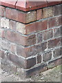
Bench mark on Lourdes Hall, next to St Anne's church
This bench mark is on an angle on the front of Lourdes Hall, which is next to St Anne's Church in Highfield Road, Rock Ferry. See also Image
Image: © John S Turner
Taken: 21 Mar 2016
0.14 miles
5
Lourdes Hall in Highfield Road/Ruskin Avenue
Lourdes Hall is on the corner of Highfield Road and Ruskin Avenue. It is the social club for St Anne's R.C. church next door. There is an Ordnance Survey bench mark on the north face of the projection on the far side of the front door - Image
Image: © John S Turner
Taken: 21 Mar 2016
0.14 miles
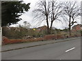
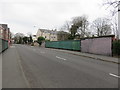
6
Development site on Victoria Drive/Rock Lane West
This development site is on the corner of Victoria Drive and Rock Lane West.
Image: © John S Turner
Taken: 21 Mar 2016
0.15 miles
7
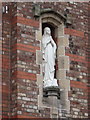
Statue set into the wall of Lourdes Hall, Rock Ferry
This statue is set into the north wall of Lourdes Hall, which is the Social Club for St Anne's church next door. I presume, therefore, that it is a statue of St Anne.
Image: © John S Turner
Taken: 21 Mar 2016
0.15 miles
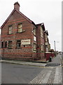
9
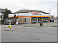
SAFECLIMB at New Chester Road/Rock Lane West junction
Looking across New Chester Road towards SAFECLIMB whose official address is #1-3 Rock Lane West. There is an Ordnance Survey bench mark on the brick wall on the left behind the company van - Image
Image: © John S Turner
Taken: 21 Mar 2016
0.15 miles
10
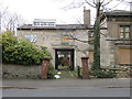
The carriage entrance for #143 Highfield Road, Rock Ferry
See also Image
Image: © John S Turner
Taken: 21 Mar 2016
0.15 miles