IMAGES TAKEN NEAR TO
Thompson Street, BIRKENHEAD, CH41 9ED
Introduction
This page details the photographs taken nearby to Thompson Street, CH41 9ED by members of the Geograph project.
The Geograph project started in 2005 with the aim of publishing, organising and preserving representative images for every square kilometre of Great Britain, Ireland and the Isle of Man.

There are currently over 7.5m images from over14,400 individuals and you can help contribute to the project by visiting https://www.geograph.org.uk
Image Map (Loading...)


Getting Data...Please wait
Leaflet Map data © OpenStreetMap
Images are licensed for reuse under creativecommons.org/licenses/by-sa/2.0
Notes
- Clicking on the map will re-center to the selected point.
- The higher the marker number, the further away the image location is from the centre of the postcode.
Image Listing (36 Images Found)
Images are licensed for reuse under creativecommons.org/licenses/by-sa/2.0
Image
Details
Distance
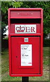
1
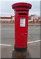
George V postbox on the B5148, Birkenhead
Postbox No. CH42 85.
Image: © JThomas
Taken: 25 May 2019
0.08 miles
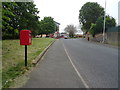
2
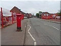
B5148, Birkenhead
Showing position of Postbox No. CH42 85.
Image: © JThomas
Taken: 25 May 2019
0.08 miles
3
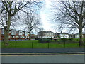
A green oasis in Tranmere
View from Church Road
Image: © Raymond Knapman
Taken: 4 Apr 2014
0.08 miles
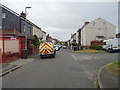
6

Church Road, Birkenhead
Looking south west on the B5148.
Image: © JThomas
Taken: 25 May 2019
0.10 miles

9
Whetstone Lane, Birkenhead
Showing position of Postbox No. CH42 206.
Image: © JThomas
Taken: 25 May 2019
0.14 miles
10
Elizabeth II postbox on Whetstone Lane, Birkenhead
Postbox No. CH42 260.
Image: © JThomas
Taken: 25 May 2019
0.15 miles