IMAGES TAKEN NEAR TO
Prince Edward Street, BIRKENHEAD, CH41 4HT
Introduction
This page details the photographs taken nearby to Prince Edward Street, CH41 4HT by members of the Geograph project.
The Geograph project started in 2005 with the aim of publishing, organising and preserving representative images for every square kilometre of Great Britain, Ireland and the Isle of Man.

There are currently over 7.5m images from over14,400 individuals and you can help contribute to the project by visiting https://www.geograph.org.uk
Image Map (Loading...)


Getting Data...Please wait
Leaflet Map data © OpenStreetMap
Images are licensed for reuse under creativecommons.org/licenses/by-sa/2.0
Notes
- Clicking on the map will re-center to the selected point.
- The higher the marker number, the further away the image location is from the centre of the postcode.
Image Listing (55 Images Found)
Images are licensed for reuse under creativecommons.org/licenses/by-sa/2.0
Image
Details
Distance
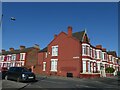
1
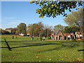
Park gates on Park Road North Birkenhead
Image: © Raymond Knapman
Taken: 30 Aug 2012
0.06 miles
2
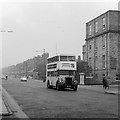
Wallasey Corporation bus 41 on Park Road North, Birkenhead ? 1967
Route 11 was one of a number of routes linking Wallasey and Birkenhead operated jointly by the two municipal transport departments. No.41 is a Leyland PD2 with Metro-Cammell bodywork, built in 1951. This was essentially a pre-war design of bodywork and was looking very old-fashioned by this time.
A feature of the view is the absence of traffic on what was and still is a major road, even allowing for the fact that the picture was taken on a Sunday.
The building on the right is part of the old Birkenhead General Hospital, demolished in the 1980s when the new Arrowe Park Hospital was developed.
Image: © Alan Murray-Rust
Taken: 17 Oct 1965
0.07 miles
3
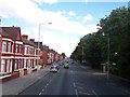
Terraced houses, corner of Park Road North and Arthur Street, Birkenhead Park
The corner building has some ornate bargeboards
Image: © David Smith
Taken: 28 Apr 2024
0.10 miles
4
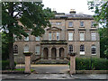
Royden House, Conway Street, Birkenhead
Remarkably lavish, though built as a pair of houses, c1843, as "part of the original development of Birkenhead Park". Grade II listed.
Now further subdivided into flats.
Image: © Stephen Richards
Taken: 22 Aug 2014
0.10 miles
6
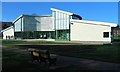
The new pavilion at Birkenhead Park
This was opened in 2006 by the Duke of Gloucester, but not quite finished yet. It is an information point, gallery and conference/ function facility.
Image: © Peter Craine
Taken: 11 Feb 2007
0.12 miles
7
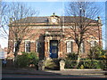
The John Laird Centre, Park Road North
Born in Greenock, Scotland, John Laird was one of Birkenhead's most famous sons and also its first mayor. A partner in the family shipbuilding firm of Laird Brothers in Birkenhead, the shipyard quickly established a name for itself in the building ships of iron and between 1829 and 1947, over 1,100 vessels of all sizes and types slid down the Laird slipways into the Mersey.He is buried in the grounds of Birkenhead Priory, next to his yard. His statue stands in Hamilton Square in the centre of Birkenhead.
Image: © Sue Adair
Taken: 1 Dec 2006
0.12 miles
8
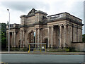
Gateway, Conway Street, Birkenhead
The main ("grand") entrance to Birkenhead Park is a majestic affair. The central arch is flanked by a pair of lodges and the whole bristles with Ionic columns. By John Robertson and Lewis Hornblower, c1845. Grade II* listed.
Birkenhead Park, which opened in 1847, was the first publicly-funded park in the country. Joseph Paxton conceived the overall plan, his pupil Edward Kemp supervised work, and Robertson and Hornblower designed most of the buildings.
Image: © Stephen Richards
Taken: 22 Aug 2014
0.14 miles
9

Entrance to Birkenhead Park
Off Park Road North, Birkenhead
Image: © JThomas
Taken: 1 Mar 2014
0.14 miles
10
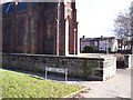
St Anne's Grove next Christ the King Church
Image: © Raymond Knapman
Taken: 3 Feb 2011
0.14 miles