IMAGES TAKEN NEAR TO
Grange Pavement, Grange Precinct, BIRKENHEAD, CH41 2RD
Introduction
This page details the photographs taken nearby to Grange Pavement, Grange Precinct, CH41 2RD by members of the Geograph project.
The Geograph project started in 2005 with the aim of publishing, organising and preserving representative images for every square kilometre of Great Britain, Ireland and the Isle of Man.

There are currently over 7.5m images from over14,400 individuals and you can help contribute to the project by visiting https://www.geograph.org.uk
Image Map (Loading...)


Getting Data...Please wait
Leaflet Map data © OpenStreetMap
Images are licensed for reuse under creativecommons.org/licenses/by-sa/2.0
Notes
- Clicking on the map will re-center to the selected point.
- The higher the marker number, the further away the image location is from the centre of the postcode.
Image Listing (97 Images Found)
Images are licensed for reuse under creativecommons.org/licenses/by-sa/2.0
Image
Details
Distance
1
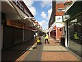
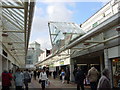
The Pyramids shopping centre, Birkenhead
One of the public walkways within the Pyramids Shopping Centre in Birkenhead.
Image: © Graham Robson
Taken: 2 Apr 2017
0.01 miles
2
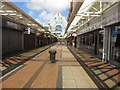
Princes Pavement, Pyramids Shopping Centre, Birkenhead
One of the public walkways within the Pyramids shopping complex in Birkenhead.
Image: © Graham Robson
Taken: 2 Apr 2017
0.05 miles
3
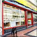
Birkenhead Cash Converters
Nothing says 'welcome to Birkenhead' quite like being stared down by a fierce dog tethered to a Cash Converters.
Image: © Matt Harrop
Taken: 5 Oct 2016
0.05 miles
4
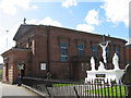
St. Werburgh's RC Church, Birkenhead
St. Werburgh's Roman Catholic church was built in 1834 and is situated on Grange Road close to the many shops of the town centre.
Image: © Sue Adair
Taken: 18 Apr 2007
0.06 miles
5
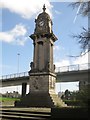
Edward VII Memorial Clock, Birkenhead
An ornate clock tower built to commemorate the life of King Edward VII. The structure is grade II listed (link: https://historicengland.org.uk/listing/the-list/list-entry/1217901 ).
Image: © Graham Robson
Taken: 2 Apr 2017
0.08 miles
6
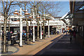
Pyramids Shopping Centre
An open-air section of Birkenhead's major shopping centre.
Image: © Stephen McKay
Taken: 5 Apr 2018
0.08 miles
7
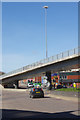
Borough Road Flyover, Birkenhead
The flyover here was built around 1970 as part of a system to manage traffic heading for the Mersey Tunnel. It rather awkwardly divides the town centre for Birkenhead Central railway station.
Image: © Stephen McKay
Taken: 5 Apr 2018
0.08 miles
8
The Grange Shopping Centre
Part of the modern complex of modern retail development in the centre of Birkenhead
Image: © Alan Murray-Rust
Taken: 5 Oct 2008
0.09 miles
9
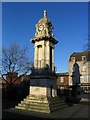
Memorial to King Edward VII, Birkenhead
This is on the roundabout by Birkenhead Central railway station. There is interesting information on Edward VII (eldest son of Queen Victoria) at http://www.spartacus.schoolnet.co.uk/MOedwardVII.htm and more information on the monument can be found at http://www.pmsa.org.uk/pmsa-database/5018/ .
The inscription on the monument reads "KING EDWARD VII MEMORIAL A.D. 1901 - 1910 ERECTED BY PUBLIC CONTRIBUTIONS. ARTHUR W. WILLMER MAYOR A.D. 1911"
The period 1901-1910 refers to his years of reign.
The monument is also used as a meeting place for Goths and Moshers.
Image: © Peter Craine
Taken: 23 Jan 2007
0.10 miles
10
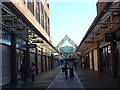
Birkenhead Shopping Centre
Birkenhead town centre with the Pyramids Shopping centre in the background.
Image: © Sue Adair
Taken: 16 Mar 2006
0.10 miles