IMAGES TAKEN NEAR TO
Borough Road, BIRKENHEAD, CH41 2RB
Introduction
This page details the photographs taken nearby to Borough Road, CH41 2RB by members of the Geograph project.
The Geograph project started in 2005 with the aim of publishing, organising and preserving representative images for every square kilometre of Great Britain, Ireland and the Isle of Man.

There are currently over 7.5m images from over14,400 individuals and you can help contribute to the project by visiting https://www.geograph.org.uk
Image Map (Loading...)


Getting Data...Please wait
Leaflet Map data © OpenStreetMap
Images are licensed for reuse under creativecommons.org/licenses/by-sa/2.0
Notes
- Clicking on the map will re-center to the selected point.
- The higher the marker number, the further away the image location is from the centre of the postcode.
Image Listing (31 Images Found)
Images are licensed for reuse under creativecommons.org/licenses/by-sa/2.0
Image
Details
Distance
2
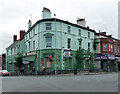
Former pub, Oxton Road, Birkenhead
Its latest incarnation was the Leprechaun, which explains the vibrant colour scheme. In another life it was the Park Hotel.
Although it has since been given a lick of paint it does not appear to have been given a new purpose in life.
Image: © Stephen Richards
Taken: 20 Aug 2014
0.06 miles
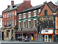
3
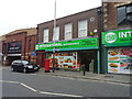
Shops on Oxton Road, Birkenhead
Showing position of Postbox No. CH41 460.
Image: © JThomas
Taken: 25 May 2019
0.06 miles
4
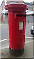
Elizabeth II postbox on Oxton Road, Birkenhead
Postbox No. CH41 460.
Image: © JThomas
Taken: 25 May 2019
0.06 miles
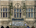
5
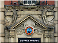
Detail of 257 Grange Road, Birkenhead
Spirited and rather free detail to the entrance of this building: Image
Image: © Stephen Richards
Taken: 20 Aug 2014
0.06 miles
6
257 Grange Road, Birkenhead
Built c1900 as a bank, according to the listing. Decorative entrance: Image Grade II listed.
At the time Caffe Bien, a "coffee house".
Image: © Stephen Richards
Taken: 20 Aug 2014
0.06 miles
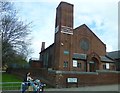
7
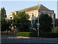
Birkenhead Central Library
This was opened in 1934 by King George V. The road in the foreground is Borough Road, one of the main ones in Birkenhead. This particular area used to be known as "Happy Valley" - I'm not sure why... but there was a pub of the same name nearby. Borough Road, incidentally, used to be a river.
Image: © Peter Craine
Taken: 19 Jul 2006
0.07 miles
8
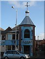
Yates' Bar, Exmouth Street
Yates' Bar in Exmouth Street with its unusual tower complete with a weather vane that looks like a kookaburra.
Image: © Sue Adair
Taken: 1 Dec 2006
0.07 miles
9
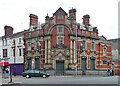
Charing Cross, Grange Road, Birkenhead
A John Smith's pub, the building looking mid C19th.
Next door is an early C20th bank building, occupied by Natwest.
Image: © Stephen Richards
Taken: 20 Aug 2014
0.08 miles
10
Detail of 1-7 Charing Cross, Birkenhead
Gothic detail to this building Image
Image: © Stephen Richards
Taken: 20 Aug 2014
0.08 miles