IMAGES TAKEN NEAR TO
Beaufort Road, BIRKENHEAD, CH41 1HQ
Introduction
This page details the photographs taken nearby to Beaufort Road, CH41 1HQ by members of the Geograph project.
The Geograph project started in 2005 with the aim of publishing, organising and preserving representative images for every square kilometre of Great Britain, Ireland and the Isle of Man.

There are currently over 7.5m images from over14,400 individuals and you can help contribute to the project by visiting https://www.geograph.org.uk
Image Map
Images are licensed for reuse under creativecommons.org/licenses/by-sa/2.0
Notes
- Clicking on the map will re-center to the selected point.
- The higher the marker number, the further away the image location is from the centre of the postcode.
Image Listing (17 Images Found)
Images are licensed for reuse under creativecommons.org/licenses/by-sa/2.0
Image
Details
Distance
2
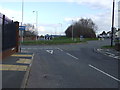
Corporation Road, Birkenhead
Heading east towards roundabout.
Image: © JThomas
Taken: 1 Mar 2014
0.05 miles
4
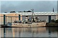
HMS Bronington (M1115), West Float, Birkenhead
A mahogany-hulled minesweeper, decommissioned around 1988. Prince Charles commanded this vessel in 1976. Laid up in Gilbrook Basin, seen from Cheshire's Quay.
Image: © El Pollock
Taken: 11 Jun 2015
0.11 miles
5
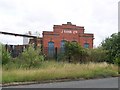
J. Rank Building, Beaufort Road
This building is the last visible remnant of the J. Rank flour mill in Birkenhead. The building is situated on Beaufort Road. In front of the spiked railings, in amongst the grass, is the trackwork of the dock branch railway line.
Image: © El Pollock
Taken: 18 Jul 2009
0.11 miles
6
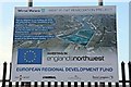
West Float Remediation Project notice, Birkenhead
On Beaufort Road, approximately at the furthest right corner of the outline in the picture, or a bit below it. The land outlined is partly intended for an International Trade Centre.
Image: © El Pollock
Taken: 11 Jun 2015
0.16 miles
7
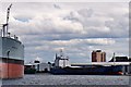
Serdolik, Cavendish Wharf, West Float, Birkenhead
Seen from Cheshire's Quay, Russian general cargo ship Serdolik (Сердолик, IMO: 9555333) is on West Float, opposite RFA Orangeleaf (A110), with the bow of cargo ship Serklow Forest (IMO: 9527685) appearing behind. In the background, the tower block is Neston Gardens, located next to Beckwith Street.
Image: © El Pollock
Taken: 21 Jun 2015
0.17 miles
8
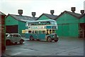
Birkenhead Transport bus at Laird Street depot, 1965
Still (2020) in use as a bus depot by Arriva, although the sheds seen in this view have been demolished and it is now an open parking area.
The bus is the archetypal bus of the Birkenhead fleet of the late 50s and early 60s, being a Leyland PD2 with bodywork by Massey Bros of Wigan. Birkenhead Transport was Massey's largest customer over the year. No.68 was one of the batch delivered in 1962.
Image: © Alan Murray-Rust
Taken: 12 Dec 1965
0.17 miles
9
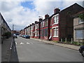
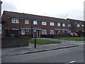
Birkenhead: Carrington Street
Carrington Street is one of the areas in the Wirral that is currently being appraised as part of the Government's Housing Market Renewal Initiative.
Image: © Nigel Cox
Taken: 17 Jun 2007
0.18 miles
10

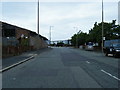
Vauxhall Works, Birkenhead
Steel fabrication factory on Beaufort Road
Image: © Eirian Evans
Taken: 13 May 2015
0.19 miles