IMAGES TAKEN NEAR TO
Tulip Avenue, BIRKENHEAD, CH41 0EB
Introduction
This page details the photographs taken nearby to Tulip Avenue, CH41 0EB by members of the Geograph project.
The Geograph project started in 2005 with the aim of publishing, organising and preserving representative images for every square kilometre of Great Britain, Ireland and the Isle of Man.

There are currently over 7.5m images from over14,400 individuals and you can help contribute to the project by visiting https://www.geograph.org.uk
Image Map (Loading...)


Getting Data...Please wait
Leaflet Map data © OpenStreetMap
Images are licensed for reuse under creativecommons.org/licenses/by-sa/2.0
Notes
- Clicking on the map will re-center to the selected point.
- The higher the marker number, the further away the image location is from the centre of the postcode.
Image Listing (6 Images Found)
Images are licensed for reuse under creativecommons.org/licenses/by-sa/2.0
Image
Details
Distance
1

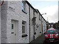
Winter Scene 2006
Snow on the Wirral, March 2006
Image: © Rob Hadfield
Taken: 12 Mar 2006
0.12 miles
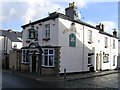
3
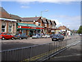
Claughton Village
The main row of shops along the main road of Claughton Village.
Image: © David Quinn
Taken: 21 Jun 2006
0.19 miles
4
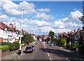
Upton Road in Claughton Birkenhead
Liverpool C of E Cathedral in background
Image: © Raymond Knapman
Taken: 30 Aug 2012
0.23 miles
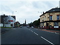
6
Heather Brow, Heather Brow, Birkenhead
Image: © Alex McGregor
Taken: 20 Oct 2011
0.25 miles