IMAGES TAKEN NEAR TO
Mold Road, CHESTER, CH4 0EW
Introduction
This page details the photographs taken nearby to Mold Road, CH4 0EW by members of the Geograph project.
The Geograph project started in 2005 with the aim of publishing, organising and preserving representative images for every square kilometre of Great Britain, Ireland and the Isle of Man.

There are currently over 7.5m images from over14,400 individuals and you can help contribute to the project by visiting https://www.geograph.org.uk
Image Map
Images are licensed for reuse under creativecommons.org/licenses/by-sa/2.0
Notes
- Clicking on the map will re-center to the selected point.
- The higher the marker number, the further away the image location is from the centre of the postcode.
Image Listing (7 Images Found)
Images are licensed for reuse under creativecommons.org/licenses/by-sa/2.0
Image
Details
Distance
1
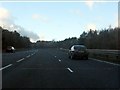
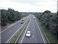
A55 west of the A5104
On the left, the westbound entry slip road joins the main carriageway.
Image: © Peter Whatley
Taken: 18 Jan 2011
0.10 miles
2
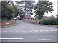
Warren Hall Court
Modern Housing development close to Broughton.
Image: © Dennis Turner
Taken: 1 Sep 2005
0.14 miles
3
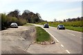
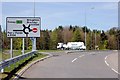
Lay-by beside the A5104
The A5104 heading towards Penyffordd.
Image: © Jeff Buck
Taken: 2 May 2013
0.14 miles
4
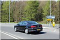
The A5104 to Penyfford
The A5104 from the roundabout near the A55 slip road.
Image: © Jeff Buck
Taken: 2 May 2013
0.18 miles
5
Roundabout on the A5104
Roundabout near the A55 slip road.
Image: © Jeff Buck
Taken: 2 May 2013
0.21 miles
6
A55 on Warren Mountain
View east near Oak Farm.
Image: © Dennis Turner
Taken: 1 Sep 2005
0.22 miles
7
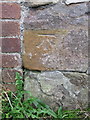
Bench mark on Warren Bank Farm outbuilding
This Ordnance Survey bench mark is on the remains of an old stone outbuilding at Warren Bank Farm. The old stone wall has been included in a later brick building. See also Image
Image: © John S Turner
Taken: 9 Oct 2017
0.25 miles