IMAGES TAKEN NEAR TO
Ewart Street, CHESTER, CH4 0BR
Introduction
This page details the photographs taken nearby to Ewart Street, CH4 0BR by members of the Geograph project.
The Geograph project started in 2005 with the aim of publishing, organising and preserving representative images for every square kilometre of Great Britain, Ireland and the Isle of Man.

There are currently over 7.5m images from over14,400 individuals and you can help contribute to the project by visiting https://www.geograph.org.uk
Image Map
Images are licensed for reuse under creativecommons.org/licenses/by-sa/2.0
Notes
- Clicking on the map will re-center to the selected point.
- The higher the marker number, the further away the image location is from the centre of the postcode.
Image Listing (80 Images Found)
Images are licensed for reuse under creativecommons.org/licenses/by-sa/2.0
Image
Details
Distance
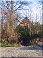
2
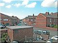
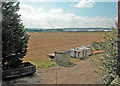
View from the bridge
Behind the houses in Ewart Street.
Image: © Dennis Turner
Taken: 15 Aug 2005
0.06 miles
3
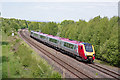
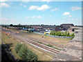
Trains at Mold Junction - May 2017 (2)
A Virgin Trains "Voyager" diesel set heads east towards Mold Junction with the 08.55 passenger service from Holyhead to London Euston.
Image: © The Carlisle Kid
Taken: 4 May 2017
0.07 miles
4
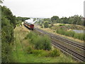
The Welsh Mountaineer leaves Mold Junction
The Welsh Mountaineer day excursion is seen here leaving Mold Junction hauled by The Sherwood Forester 45231 Stanier Class 5 locomotive. The trip is from Preston to Blaenau Ffestiniog and return. The wide grassy area on the left is where the actual Mold branch line once ran, veering to the left just about where the carriages are in the photo.
Image: © John S Turner
Taken: 26 Aug 2009
0.07 miles
5
Railway Line Saltney Ferry
North Wales coast railway line just before Mold Junction.
Image: © Dennis Turner
Taken: 15 Aug 2005
0.08 miles
8
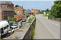
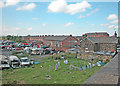
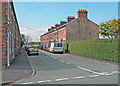
Saltney Ferry Road
A view along the B5129 from the railway bridge. Ewart Street leads off to the left.
Image: © Stephen McKay
Taken: 14 Jun 2018
0.10 miles
9
The destruction of St Matthew's Saltney Ferry - Overgrown gateway
On the evening of 11th December 2008 the redundant church of St Matthew’s, Saltney Ferry was destroyed by fire. This is the overgrown entrance from Saltney Ferry Road. Four days after the fire there were still no restrictions on access to the site.
St Matthew’s was built in 1911 to provide for the needs of the expanding railway community at Mold Junction. Due to a dwindling congregation the church became redundant in June 2000 and, coincidentally, the church hall was burnt down about five years ago.
Image: © John S Turner
Taken: 15 Dec 2008
0.10 miles
10
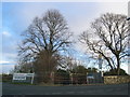
The destruction of St Matthew's Saltney Ferry - The gateway
On the evening of 11th December 2008 the redundant church of St Matthew’s, Saltney Ferry was destroyed by fire. This view is across Saltney Ferry Road towards the gateway to the church grounds. The church would have been seen between the two trees. Less than ten days after the fire the shell was demolished, the site made safe, and then it was secured. A sad end to a building that had served the community well for nearly one hundred years.
St Matthew’s was built in 1911 to provide for the needs of the expanding railway community at Mold Junction. Due to a dwindling congregation the church became redundant in June 2000 and, coincidentally, the church hall was burnt down about five years ago.
Image: © John S Turner
Taken: 22 Dec 2008
0.10 miles