IMAGES TAKEN NEAR TO
Church Bank, CHESTER, CH3 9QE
Introduction
This page details the photographs taken nearby to Church Bank, CH3 9QE by members of the Geograph project.
The Geograph project started in 2005 with the aim of publishing, organising and preserving representative images for every square kilometre of Great Britain, Ireland and the Isle of Man.

There are currently over 7.5m images from over14,400 individuals and you can help contribute to the project by visiting https://www.geograph.org.uk
Image Map
Images are licensed for reuse under creativecommons.org/licenses/by-sa/2.0
Notes
- Clicking on the map will re-center to the selected point.
- The higher the marker number, the further away the image location is from the centre of the postcode.
Image Listing (24 Images Found)
Images are licensed for reuse under creativecommons.org/licenses/by-sa/2.0
Image
Details
Distance
3
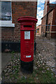
Edward VII (1901-1910) Post Box, Tattenhall
Image: © Brian Deegan
Taken: 10 Sep 2022
0.05 miles
4
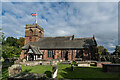
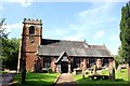
St. Alban's Church, Tattenhall
It is thought that a church may have existed on this site at the time of the Norman conquest. The tower and parts of the present church date from the early 16th century. The church was restored and largely remodelled in 1869–70. During this time the remains of an earlier church which had been destroyed by fire were discovered. Also discovered were a skeleton of a large man outside the north wall and a coffin containing bones under the floor of the church.
https://en.wikipedia.org/wiki/St_Alban%27s_Church,_Tattenhall
Image: © Brian Deegan
Taken: 10 Sep 2022
0.05 miles
5
St Alban's Church, Tattenhall
It is thought that a church may have existed on this site at the time of the Norman conquest. The tower and parts of the present church date from the early 16th century. The church was restored and largely remodelled in 1869–70 by John Douglas. During this time the remains of an earlier church which had been destroyed by fire were discovered. Also discovered were a skeleton of a large man outside the north wall and a coffin containing bones under the floor of the church.
http://en.wikipedia.org/wiki/St_Alban%27s_Church,_Tattenhall
Image: © Jeff Buck
Taken: 9 Aug 2012
0.05 miles
6
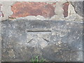
Ordnance Survey Cut Mark
This can be found on the roadside wall of a building in High Street, Tattenhall.
For more detail see : http://www.bench-marks.org.uk/bm80590
Image: © Peter Wood
Taken: 2 Dec 2016
0.06 miles
7

Edward VII postbox, Tattenhall Post Office
Postbox No. CH3 223.
See Image] for context.
Image: © JThomas
Taken: 12 Nov 2016
0.06 miles
8
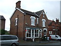
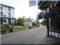
Tattenhall Post Office
Showing position of Postbox No. CH3 223.
See Image] for postbox.
Image: © JThomas
Taken: 12 Nov 2016
0.06 miles
9
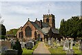
St Alban's Church
St Alban's Church in Tattenhall.
Image: © Peter McDermott
Taken: 30 Apr 2022
0.06 miles
10
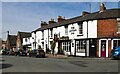
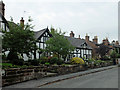
Tattenhall
The Letters Inn in Tattenhall.
Image: © Peter McDermott
Taken: 30 Apr 2022
0.06 miles