IMAGES TAKEN NEAR TO
Burwardsley Road, CHESTER, CH3 9NW
Introduction
This page details the photographs taken nearby to Burwardsley Road, CH3 9NW by members of the Geograph project.
The Geograph project started in 2005 with the aim of publishing, organising and preserving representative images for every square kilometre of Great Britain, Ireland and the Isle of Man.

There are currently over 7.5m images from over14,400 individuals and you can help contribute to the project by visiting https://www.geograph.org.uk
Image Map
Images are licensed for reuse under creativecommons.org/licenses/by-sa/2.0
Notes
- Clicking on the map will re-center to the selected point.
- The higher the marker number, the further away the image location is from the centre of the postcode.
Image Listing (24 Images Found)
Images are licensed for reuse under creativecommons.org/licenses/by-sa/2.0
Image
Details
Distance
1
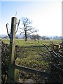
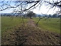
Footpath from Burwardsley Road, Tattenhall to Dark Lane
Where the footpath leaves Burwardsley Road the two footpath signs are conflicting. The yellow sign is correct, indicating that the path follows the tree line to the prominent tree in the photo and then veers right to continue on the hedge line. Next see Image
Image: © John S Turner
Taken: 7 Feb 2007
0.04 miles
2
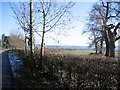
Tree Line near Tattenhall
Viewed from Burwardsley Road, Tattenhall, this old tree line is pointing towards Cheshire's sandstone ridge. The footpath to Dark Lane begins a few yards further along the road.
Image: © John S Turner
Taken: 7 Feb 2007
0.06 miles
3
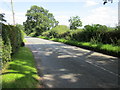
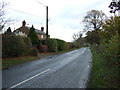
Burwardsley Road, Tattenhall
Burwardsley Road as it heads out of Tattenhall.
Image: © Jeff Buck
Taken: 9 Aug 2012
0.10 miles
4
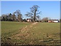
Footpath from Dark Lane to Burwardsley Road
The footpath follows the hedge line and then veers left at the prominent tree. It joins Burwardsley Road near the large house on the left.
Image: © John S Turner
Taken: 7 Feb 2007
0.11 miles
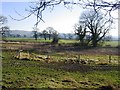
5
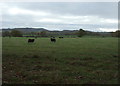
Black sheep east of Tattenhall
South of Burwardsley Road.
Image: © JThomas
Taken: 12 Nov 2016
0.13 miles
6
Footpath from Burwardsley Road to Dark Lane #2
This old hedge line indicates the new line of the footpath from Burwardsley Road, as it changes direction on its way towards Dark Lane. Next see Image
Image: © John S Turner
Taken: 7 Feb 2007
0.13 miles
7
Burwardsley Road
Heading east on National Cycle Route 45.
Image: © JThomas
Taken: 12 Nov 2016
0.14 miles
8
Footpath from Dark Lane to Burwardsley Road
Looking from the low lying area along the tree line that marks the line of the footpath. The houses in the distance are on Burwardsley Road.
Image: © John S Turner
Taken: 7 Feb 2007
0.16 miles
9
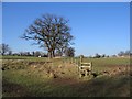
Footpath from Dark Lane to Burwardsley Road
Looking across the double stile and bridge over the drainage ditch, and the low lying area. The tree line directly ahead indicates the line of the footpath to Burwardsley Road where the houses can be seen.
Image: © John S Turner
Taken: 7 Feb 2007
0.20 miles
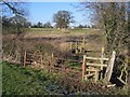
10
Footpath from Burwardsley Road to Dark Lane #3
The path crosses a low lying area here, and a drainage ditch. The first stile is to the left and the second one straight ahead. Next see Image
Image: © John S Turner
Taken: 7 Feb 2007
0.21 miles