IMAGES TAKEN NEAR TO
Back Lane, CHESTER, CH3 9NJ
Introduction
This page details the photographs taken nearby to Back Lane, CH3 9NJ by members of the Geograph project.
The Geograph project started in 2005 with the aim of publishing, organising and preserving representative images for every square kilometre of Great Britain, Ireland and the Isle of Man.

There are currently over 7.5m images from over14,400 individuals and you can help contribute to the project by visiting https://www.geograph.org.uk
Image Map
Images are licensed for reuse under creativecommons.org/licenses/by-sa/2.0
Notes
- Clicking on the map will re-center to the selected point.
- The higher the marker number, the further away the image location is from the centre of the postcode.
Image Listing (11 Images Found)
Images are licensed for reuse under creativecommons.org/licenses/by-sa/2.0
Image
Details
Distance
1
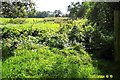
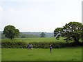
Cheshire Plain - farmland
View due S from footpath Beeston 28. Lush farmland on the Cheshire Plain, in the parish of Beeston just west of the Peckforton Hills. Formerly part of the Peckforton Estate, now owned by Woodhouse Farm to the west. Line of trees on the right marks the course of Crimes Brook that marks the boundary with Tattenhall - beware, there's no bridge across the brook! Although much of the Cheshire Plain is intensively farmed, there are many little unkempt corners like this that are rich in flora and wildlife.
Image: © Mike Harris
Taken: 10 Oct 2004
0.12 miles
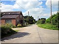
2
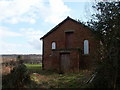
Derelict Chapel near Burwardsley
This chapel has been used as an agricultural building for many years, but is now for sale or rent for small industrial use.
Image: © John Lindsay
Taken: 17 Mar 2008
0.13 miles
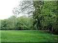
3
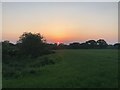
View from footpath skirting Pennsylvania Wood
Image: © Philip Cornwall
Taken: 28 May 2018
0.15 miles
5
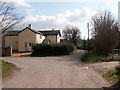
Butler's Cottage near Burwardsley
At the junction of Wood Lane and Back Lane
Image: © John Lindsay
Taken: 17 Mar 2008
0.18 miles
6
Wood Farm, Wood Lane near Burwardsley
Wood Farm at the junction of Back Lane and Wood Lane near Burwardsley.
Image: © Jeff Buck
Taken: 9 Aug 2012
0.18 miles
7
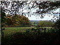
Tattenhall - the Eddisbury Way
Tattenhall. View along the Eddisbury Way with Pennsylvania Wood and the Peckforton Hills. Near Yewtree Farm at the junction of Tattenhall footpaths 18, 26 and 27.
Image: © Mike Harris
Taken: 11 May 2008
0.19 miles
8
Beeston - Pennsylvania Wood
Beeston. Corner of Pennsylvania Wood on Beeston footpath 29 at its junction with footpath 30 and Tattenhall footpath 27.
Image: © Mike Harris
Taken: 11 May 2008
0.20 miles
9
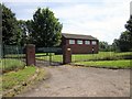
Pumping Station on Brick Lane, Beeston
The second of two water pumping stations on Back Lane, Beeston. The lettering on the old gates read 'Staffordshire Potteries Water Board'.
Image: © Jeff Buck
Taken: 9 Aug 2012
0.20 miles
10
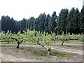
Tattenhall - orchard beside the Eddisbury Way
Tattenhall. Orchard and wind break on the Eddisbury Way (Wood Lane) near Wood Farm. This type of scene is more typical of the hillsides near Kelsall further north. SJ 5158 is fairly flat and dominated by dairy pasture. The conifer belts provide a wind break on the exposed Cheshire Plain.
Image: © Mike Harris
Taken: 11 May 2008
0.24 miles