IMAGES TAKEN NEAR TO
Aldersey Lane, CHESTER, CH3 9LR
Introduction
This page details the photographs taken nearby to Aldersey Lane, CH3 9LR by members of the Geograph project.
The Geograph project started in 2005 with the aim of publishing, organising and preserving representative images for every square kilometre of Great Britain, Ireland and the Isle of Man.

There are currently over 7.5m images from over14,400 individuals and you can help contribute to the project by visiting https://www.geograph.org.uk
Image Map
Images are licensed for reuse under creativecommons.org/licenses/by-sa/2.0
Notes
- Clicking on the map will re-center to the selected point.
- The higher the marker number, the further away the image location is from the centre of the postcode.
Image Listing (35 Images Found)
Images are licensed for reuse under creativecommons.org/licenses/by-sa/2.0
Image
Details
Distance
1
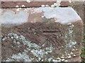
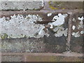
Ordnance Survey Cut Mark
This can be found on the wall of St Mary's Church in Coddington.
For more detail see : http://www.bench-marks.org.uk/bm80921
Image: © Peter Wood
Taken: 2 Dec 2016
0.02 miles
2
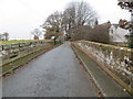
Coddington St Mary from Aldersey Lane
A view of St Mary's, Coddington from Aldersey Lane. The church is built in Cheshire sandstone, as is the 18th century wall fronting the lane. The walls flanking the steps are neater, so may be later in date.
Image: © John S Turner
Taken: 19 Apr 2007
0.02 miles
3
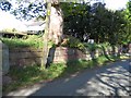
Graveyard Wall at Coddington St Mary
Viewed from Aldersey lane, this section of the graveyard wall runs between the church steps on the left, see Image, and the gate to the old rectory on the right. About halfway along, between the wooden pole and the rectory gate, there is an inscribed stone with the name of at least one church warden, and the date 1748. This stone would seem to date the wall. Also see Image .
Image: © John S Turner
Taken: 19 Apr 2007
0.02 miles
4
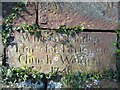
Inscribed Stone at Coddington St Mary
This stone is part of the church graveyard wall that flanks the road to Aldersey. It records the names of one or two church wardens in 1748, although I'm not at all sure of what the second line says. The wall would seem to date to the same time.
William Lindop
(? of ?) Parsonage
Church Warden(s?)
1748
Image: © John S Turner
Taken: 19 Apr 2007
0.02 miles
5
Aldersley Lane at Coddington Bridge
Looking north-westward.
Image: © Peter Wood
Taken: 2 Dec 2016
0.02 miles
6
Stile and Road Signs at Coddington
The footpath across the field Image emerges on to the road near the church via this stile. The old sandstone bridge Image is protected by the maximum weight sign. Aldersey is the next parish after Coddington, although the actual boundary is in the middle of Coddington Brook under the bridge.
Image: © John S Turner
Taken: 19 Apr 2007
0.02 miles
8
Ordnance Survey Cut Mark
This mark can be found on Coddington Bridge.
For more detail see : http://www.bench-marks.org.uk/bm80922
Image: © Peter Wood
Taken: 2 Dec 2016
0.03 miles
9
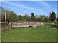
Bridge over Coddington Brook
Viewed from the footpath across the field Image the old sandstone bridge carries the minor road to Aldersey over Coddington Brook.
Image: © John S Turner
Taken: 19 Apr 2007
0.03 miles
10
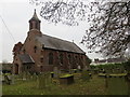
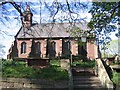
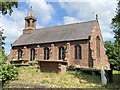
The Church of St Mary at Coddington
Viewed from the south.
Image: © Peter Wood
Taken: 2 Dec 2016
0.03 miles