IMAGES TAKEN NEAR TO
Ryecroft Lane, CHESTER, CH3 8HH
Introduction
This page details the photographs taken nearby to Ryecroft Lane, CH3 8HH by members of the Geograph project.
The Geograph project started in 2005 with the aim of publishing, organising and preserving representative images for every square kilometre of Great Britain, Ireland and the Isle of Man.

There are currently over 7.5m images from over14,400 individuals and you can help contribute to the project by visiting https://www.geograph.org.uk
Image Map
Images are licensed for reuse under creativecommons.org/licenses/by-sa/2.0
Notes
- Clicking on the map will re-center to the selected point.
- The higher the marker number, the further away the image location is from the centre of the postcode.
Image Listing (5 Images Found)
Images are licensed for reuse under creativecommons.org/licenses/by-sa/2.0
Image
Details
Distance
1
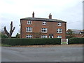
Stapleford Hall, Bruen Stapleford
Stapleford Hall seen looking north (bearing 350°) from 280m away on Bruen Stapleford footpath 3. Seat of the Bruen (earlier Bruyn) family at least since the 14th century, if not earlier. For a fascinating anecdote, giving instruction on how to increase your personal RAM, see http://www.thebookofdays.com/months/may/28.htm.
Image: © Mike Harris
Taken: 3 May 2006
0.19 miles
2
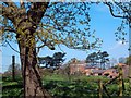
Young crop field near Cross Lanes Farm
Off Ryecroft Lane.
Image: © JThomas
Taken: 3 Dec 2016
0.20 miles
3
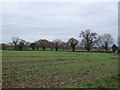
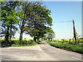
Ryecroft Lane near Cross Lanes Farm
Looking west.
Image: © JThomas
Taken: 3 Dec 2016
0.23 miles
4
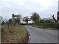
Road Junction, Bruen Stapleford
The junction of Ryecroft Lane and Broomheath Lane.
Image: © Jeff Buck
Taken: 23 May 2012
0.23 miles