IMAGES TAKEN NEAR TO
Whitegate Lane, CHESTER, CH3 8DF
Introduction
This page details the photographs taken nearby to Whitegate Lane, CH3 8DF by members of the Geograph project.
The Geograph project started in 2005 with the aim of publishing, organising and preserving representative images for every square kilometre of Great Britain, Ireland and the Isle of Man.

There are currently over 7.5m images from over14,400 individuals and you can help contribute to the project by visiting https://www.geograph.org.uk
Image Map (Loading...)


Getting Data...Please wait
Leaflet Map data © OpenStreetMap
Images are licensed for reuse under creativecommons.org/licenses/by-sa/2.0
Notes
- Clicking on the map will re-center to the selected point.
- The higher the marker number, the further away the image location is from the centre of the postcode.
Image Listing (13 Images Found)
Images are licensed for reuse under creativecommons.org/licenses/by-sa/2.0
Image
Details
Distance
2
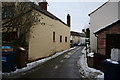
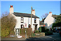
West End, Ashton Hayes
Pretty corner on a snowy day.
Image: © Dave Dunford
Taken: 10 Jan 2010
0.08 miles
4

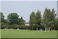
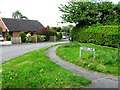
Footpath southwest of Ashton Hayes
Pleasant hedged path leading eventually to Tarvin.
Image: © Dave Dunford
Taken: 10 Jan 2010
0.11 miles
6
Ashton Post Office
The Post Office used to be in the house, where the bay window is. Now it's in the new annexe with the red sign.
Image: © Des Blenkinsopp
Taken: 7 Mar 2015
0.12 miles

9
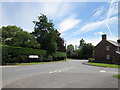
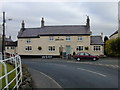
The B5393 (Ashton Lane)
At the junctions of Gongar Lane and Pentre Lane.
Image: © Jeff Buck
Taken: 1 Jul 2011
0.20 miles
10
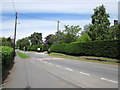
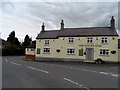
The B5393 (Ashton Lane)
The B5393, (Ashton Lane) at Ashton Hayes.
Image: © Jeff Buck
Taken: 1 Jul 2011
0.21 miles