IMAGES TAKEN NEAR TO
Grange Road, CHESTER, CH3 8AE
Introduction
This page details the photographs taken nearby to Grange Road, CH3 8AE by members of the Geograph project.
The Geograph project started in 2005 with the aim of publishing, organising and preserving representative images for every square kilometre of Great Britain, Ireland and the Isle of Man.

There are currently over 7.5m images from over14,400 individuals and you can help contribute to the project by visiting https://www.geograph.org.uk
Image Map (Loading...)


Getting Data...Please wait
Leaflet Map data © OpenStreetMap
Images are licensed for reuse under creativecommons.org/licenses/by-sa/2.0
Notes
- Clicking on the map will re-center to the selected point.
- The higher the marker number, the further away the image location is from the centre of the postcode.
Image Listing (5 Images Found)
Images are licensed for reuse under creativecommons.org/licenses/by-sa/2.0
Image
Details
Distance
1
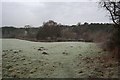
Mouldsworth from Grange Road
The start of a short footpath that links Grange Road to the B5393, viewed on a frosty January day. In the valley between here and Mouldsworth are a series of fishing lakes (not visible in this view).
Image: © Dave Dunford
Taken: 16 Jan 2016
0.11 miles
2
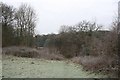
Path from Grange Road to B5393
Looking back to the point where this short but pleasant footpath leaves the field and drops into woodland between a small disused quarry and the Ashton Brook.
Image: © Dave Dunford
Taken: 16 Jan 2016
0.14 miles
3
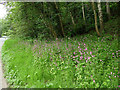
Campions by the side of Delamere Road, Mouldsworth
Image: © Stephen Craven
Taken: 1 Jun 2019
0.17 miles
4
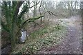
Footpath south of Mouldsworth
Short but pleasant footpath linking the B5393 with Grange Road, initially alongside the Ashton Brook.
Image: © Dave Dunford
Taken: 16 Jan 2016
0.17 miles
5
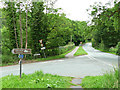
Junction of Station Road and Delamere Road, Mouldsworth
A plethora of signs includes one for a "leisure drive". The idea of driving a car only for its own sake may in years to come be seen as selfish.
Image: © Stephen Craven
Taken: 1 Jun 2019
0.21 miles