IMAGES TAKEN NEAR TO
Station Lane, CHESTER, CH3 7SX
Introduction
This page details the photographs taken nearby to Station Lane, CH3 7SX by members of the Geograph project.
The Geograph project started in 2005 with the aim of publishing, organising and preserving representative images for every square kilometre of Great Britain, Ireland and the Isle of Man.

There are currently over 7.5m images from over14,400 individuals and you can help contribute to the project by visiting https://www.geograph.org.uk
Image Map (Loading...)


Getting Data...Please wait
Leaflet Map data © OpenStreetMap
Images are licensed for reuse under creativecommons.org/licenses/by-sa/2.0
Notes
- Clicking on the map will re-center to the selected point.
- The higher the marker number, the further away the image location is from the centre of the postcode.
Image Listing (33 Images Found)
Images are licensed for reuse under creativecommons.org/licenses/by-sa/2.0
Image
Details
Distance
2

Guilden Sutton War Memorial
Guilden Sutton is a village in Cheshire. It is home to 1,525 residents at the time of the 2001 census (http://goo.gl/HvGrNO Office for National Statistics). The War Memorial takes the form of two metal panels fixed to the railings, recording the names of those from the village who lost their lives during the two World Wars (Image]).
Image: © David Dixon
Taken: 7 Sep 2015
0.04 miles
3
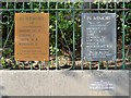
War Memorial Plaques, Guilden Sutton
Guilden Sutton is a village in Cheshire. It is home to 1,525 residents at the time of the 2001 census (http://goo.gl/HvGrNO Office for National Statistics). The War Memorial takes the form of two metal panels fixed to the railings, recording the names of those from the village who lost their lives during the two World Wars. Unusually, the Second World War plaque was installed first and the First World War plaque has been added more recently (http://www.guildensutton.org.uk/Guilden%20Sutton/War%20memorial.html GuildenSutton.org.uk)
Image: © David Dixon
Taken: 7 Sep 2015
0.04 miles
4

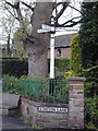
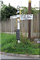
Old Direction Sign - Signpost by Station Lane, Guilden Sutton parish
Pawn finial - 3 arms; Cheshire CCC octagonal by the UC road, in parish of Guilden Sutton (Chester District), Station Lane junction with School Lane.
Surveyed
Milestone Society National ID: CH_SJ4468B
Image: © Milestone Society
Taken: Unknown
0.05 miles
5
Guide post outside The Hall, Guilden Sutton.
Image: © Stephen Charles
Taken: 16 Apr 2004
0.05 miles
6

Guilden Sutton Methodist Church
The Primitive Methodist Chapel opened in 1873 (Image]) and was closed sometime after 2010 (http://goo.gl/drlMfQ Chester Chronicle). It appears to have been converted into residential accommodation.
Image: © David Dixon
Taken: 7 Sep 2015
0.05 miles
7
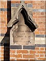
Methodist Church Memorial Stone
Commemorative tablet built into the wall of Image
Image: © David Dixon
Taken: 7 Sep 2015
0.05 miles
8

Guilden Sutton Methodist Church
Guilden Sutton Methodist Church was built in 1873.
Image: © Jeff Buck
Taken: 13 Jan 2012
0.06 miles
9

Former Primitive Methodist Church, Guilden Sutton
In a prominent position where School Lane meets Station Lane. It has been converted into a dwelling.
Image: © Eirian Evans
Taken: 22 Mar 2016
0.06 miles
10
Old Direction Sign - Signpost by Wicker Lane, Guilden Sutton
Annulus finial - 2 arms; CCC M/T Post by the UC road, in parish of Guilden Sutton (Chester District), Church Lane junction with Wicker Lane.
Surveyed
Milestone Society National ID: CH_SJ4468A
Image: © Milestone Society
Taken: Unknown
0.07 miles