IMAGES TAKEN NEAR TO
Belle Vue Lane, CHESTER, CH3 7EJ
Introduction
This page details the photographs taken nearby to Belle Vue Lane, CH3 7EJ by members of the Geograph project.
The Geograph project started in 2005 with the aim of publishing, organising and preserving representative images for every square kilometre of Great Britain, Ireland and the Isle of Man.

There are currently over 7.5m images from over14,400 individuals and you can help contribute to the project by visiting https://www.geograph.org.uk
Image Map
Images are licensed for reuse under creativecommons.org/licenses/by-sa/2.0
Notes
- Clicking on the map will re-center to the selected point.
- The higher the marker number, the further away the image location is from the centre of the postcode.
Image Listing (14 Images Found)
Images are licensed for reuse under creativecommons.org/licenses/by-sa/2.0
Image
Details
Distance
1
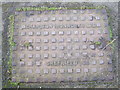
Charlton Ironworks Ltd. Sheffield, Manhole Cover
Charlton Brook foundry made cast iron manhole covers and gulley grates, exporting them at one time to most parts of the world. Between 1896 and 1944 it was owned by George Harvey and then by Tom Oxley and later Michael Oxley. The foundry closed about 1990 and the site is now covered by housing.
link:http://www.friendsofcharltonbrook.co.uk/5.html
Image: © BrianPritchard
Taken: 7 Feb 2008
0.07 miles
2
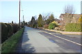
Bellevue Lane, Guilden Sutton
Wikipedia http://en.wikipedia.org/wiki/Guilden_Sutton
Image: © Jeff Buck
Taken: 14 Feb 2013
0.07 miles
3
Guilden Sutton - Middlecroft
Guilden Sutton. View down Middlecroft (road) from Belle Vue Lane. Looking east from the Longster Trail extension, which here runs along Belle Vue Lane behind the photographer.
Image: © Mike Harris
Taken: 16 Apr 2008
0.08 miles
4
Guilden Sutton - Longster Trail
Guilden Sutton. The Longster Trail (Pipers Ash spur) runs from behind the photographer along Belle Vue Lane and then straight ahead along the narrow alley beside the white house (The Orchards - 1849) as Guilden Sutton footpath 2. The new Longster Trail extension will run off to the left along Belle Vue Lane towards the disused Mickle Trafford railway.
Image: © Mike Harris
Taken: 16 Apr 2008
0.10 miles
5
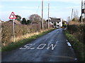
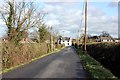
Bellevue Lane/Longster Trail, Guilden Sutton
The Longster Trail follows the route of Bellevue Lane and continues to the right of the white cottage.
Wikipedia http://en.wikipedia.org/wiki/Longster_Trail
Wikipedia http://en.wikipedia.org/wiki/Guilden_Sutton
Image: © Jeff Buck
Taken: 14 Feb 2013
0.11 miles
6
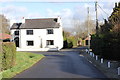
Bellevue Lane, Guiden Sutton
The road turns sharp left, just in front of the white house.
Image: © BrianPritchard
Taken: 5 Jan 2008
0.11 miles
7
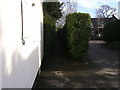
Narrow entrance for the Longster Trail
The entrance for the Longster Trail, by the side of the house on the right, was lacking a footpath sign.
Image: © BrianPritchard
Taken: 5 Jan 2008
0.12 miles
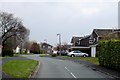
8
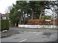
Junction of School Lane and Belle Vue Lane
Turn left for Piper's Ash and right for Guilden Sutton. The old school on the left of picture is now a private residence.
Image: © BrianPritchard
Taken: 7 Feb 2008
0.14 miles
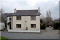
9
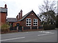
The Old School Guilden Sutton
Now converted into a dwelling.
Image: © Eirian Evans
Taken: 22 Mar 2016
0.16 miles
10
Bellevue Lane/Longster Trail, Guilden Sutton
The Longster Trail follows the route of Bellevue Lane near Guilden Sutton.
Wikipedia http://en.wikipedia.org/wiki/Longster_Trail
Wikipedia http://en.wikipedia.org/wiki/Guilden_Sutton
Image: © Jeff Buck
Taken: 14 Feb 2013
0.18 miles