IMAGES TAKEN NEAR TO
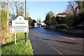
Farndon, CHESTER, CH3 6QH
Introduction
This page details the photographs taken nearby to CH3 6QH by members of the Geograph project.
The Geograph project started in 2005 with the aim of publishing, organising and preserving representative images for every square kilometre of Great Britain, Ireland and the Isle of Man.

There are currently over 7.5m images from over14,400 individuals and you can help contribute to the project by visiting https://www.geograph.org.uk
Image Map
Images are licensed for reuse under creativecommons.org/licenses/by-sa/2.0
Notes
- Clicking on the map will re-center to the selected point.
- The higher the marker number, the further away the image location is from the centre of the postcode.
Image Listing (143 Images Found)
Images are licensed for reuse under creativecommons.org/licenses/by-sa/2.0
Image
Details
Distance
1
The bottom of High Street
Looking up from the bridge over the River Dee.
Image: © Alan Murray-Rust
Taken: 9 Jun 2009
0.04 miles
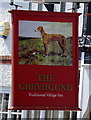
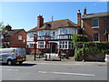
2
The Greyhound, Farndon
The Greyhound public house on Bridge Street, Farndon.
Image: © Jeff Buck
Taken: 28 Dec 2013
0.05 miles
4
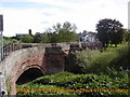
Bridge over River Dee
View from England back into Holt in Wales. Taken during my Lands End to John O'Groats cycle ride.
Image: © Patrick Pavey
Taken: 20 May 2004
0.05 miles
5
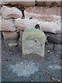
County Bridge Marker by High Street, Farndon
This old 'stone' is recorded on old maps, but its purpose is not stated. Too far from the river to be a national boundary stone, so it seems likely that it is a bridge marker stone indicating the county's responsibility for the road from this point. For a wider view see Image
Milestone Society National ID: CH_FARN01br
Image: © John S Turner
Taken: 16 Jan 2023
0.06 miles
6
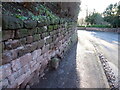
High Street, Farndon and a County Bridge Marker
Looking down High Street, Farndon in the direction of the bridge over the River Dee. On the left the old 'stone' is recorded on old maps, but its purpose is not stated. Too far from the river to be a national boundary stone, so it seems likely that it is a bridge marker stone indicating the county's responsibility for the road from this point. Image
Milestone Society National ID: CH_FARN01br
Image: © John S Turner
Taken: 16 Jan 2023
0.06 miles
7
Bridge Street, Farndon
Entering Farndon in England after crossing Farndon Bridge from Holt in Wales.
Wikipedia http://en.wikipedia.org/wiki/Farndon,_Cheshire
Image: © Jeff Buck
Taken: 28 Dec 2013
0.06 miles
8
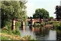
Farndon Bridge on the River Dee
Farndon Bridge was built in 1339 by Monks from St Werburgh's Abbey Chester. It originally had ten arches with a large gate tower on the fifth arch. In the 18th century the tower was demolished and at some time two of the arches on the Welsh side were lost. The bridge is a narrow structure built of red sandstone with eight arches, of which five are over the river. On the Farndon side is one flood arch and two flood arches are on the Holt side.
*Info source: Wikipedia
Image: © Jeff Buck
Taken: 27 Jul 2011
0.06 miles