IMAGES TAKEN NEAR TO
Malayan Place, CHESTER, CH3 6GJ
Introduction
This page details the photographs taken nearby to Malayan Place, CH3 6GJ by members of the Geograph project.
The Geograph project started in 2005 with the aim of publishing, organising and preserving representative images for every square kilometre of Great Britain, Ireland and the Isle of Man.

There are currently over 7.5m images from over14,400 individuals and you can help contribute to the project by visiting https://www.geograph.org.uk
Image Map
Images are licensed for reuse under creativecommons.org/licenses/by-sa/2.0
Notes
- Clicking on the map will re-center to the selected point.
- The higher the marker number, the further away the image location is from the centre of the postcode.
Image Listing (14 Images Found)
Images are licensed for reuse under creativecommons.org/licenses/by-sa/2.0
Image
Details
Distance
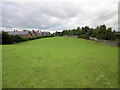
1
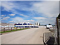
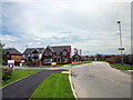
New Housing Estate, Huntington
New housing estate on the site of an old army camp at Huntington near Chester.
Image: © Jeff Buck
Taken: 26 May 2014
0.11 miles
2
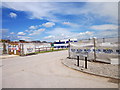
Green Howards Road, Huntington
New housing estate on the site of an old army camp at Huntington near Chester.
Image: © Jeff Buck
Taken: 26 May 2014
0.11 miles
3
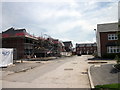
Green Howards Road, Huntington
New housing estate on the site of an old army camp at Huntington near Chester.
Image: © Jeff Buck
Taken: 26 May 2014
0.12 miles
4
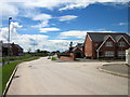
New Housing Estate, Huntington
New housing estate on the site of an old army camp at Huntington near Chester.
Image: © Jeff Buck
Taken: 26 May 2014
0.12 miles
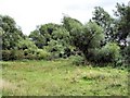
5
Pond at Huntington
The house just seen on the left is
Image: © Jeff Buck
Taken: 16 Aug 2014
0.18 miles
6
Highlander Way, Huntington
New housing estate on the site of an old army camp at Huntington near Chester.
Image: © Jeff Buck
Taken: 26 May 2014
0.19 miles
7
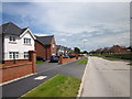
Highlander Way, Huntington
New housing estate on the site of an old army camp at Huntington near Chester.
Image: © Jeff Buck
Taken: 26 May 2014
0.19 miles
8
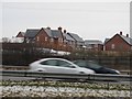
A55 and Saighton Camp
Saighton Camp, a former military training area is being redeveloped.
Image: © Richard Webb
Taken: 27 Dec 2010
0.20 miles
9
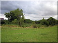
Footpath to Huntington
Heading south towards Huntington. The new housing estate on the left is on the site of the former Saighton Military Training Ground.
Image: © Jeff Buck
Taken: 16 Aug 2014
0.22 miles
10
Christleton - footpath 20
Christleton - footpath 20 - view towards Caldy Brook at the parish boundary with Huntington.
Image: © Mike Harris
Taken: 25 Aug 2008
0.23 miles