IMAGES TAKEN NEAR TO
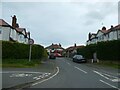
Toll Bar Road, CHESTER, CH3 5QX
Introduction
This page details the photographs taken nearby to Toll Bar Road, CH3 5QX by members of the Geograph project.
The Geograph project started in 2005 with the aim of publishing, organising and preserving representative images for every square kilometre of Great Britain, Ireland and the Isle of Man.

There are currently over 7.5m images from over14,400 individuals and you can help contribute to the project by visiting https://www.geograph.org.uk
Image Map
Images are licensed for reuse under creativecommons.org/licenses/by-sa/2.0
Notes
- Clicking on the map will re-center to the selected point.
- The higher the marker number, the further away the image location is from the centre of the postcode.
Image Listing (54 Images Found)
Images are licensed for reuse under creativecommons.org/licenses/by-sa/2.0
Image
Details
Distance
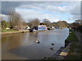
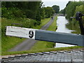
2
Shropshire Union Canal
Looking northwest from Lock No.9
Image: © Eirian Evans
Taken: 24 Feb 2016
0.06 miles
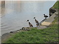
3
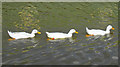
Three Ducks on the Shroppie
Three white ducks swimming on the Shropshire Union Canal near Boughton.
Image: © Jeff Buck
Taken: 23 Jul 2018
0.07 miles
4

Old Boundary Marker by the A41, Whitchurch Road, Christleton parish
Parish Boundary Marker by the A41, in parish of Christleton (Chester District), Whitchurch Road, outside No 127.
Inscription reads:-
C P
1848
Grade II listed.
List Entry Number: 1130632 https://historicengland.org.uk/listing/the-list/list-entry/1130632
Surveyed
Milestone Society National ID: CH_CHRROW01pb
Image: © Milestone Society
Taken: Unknown
0.07 miles
5
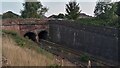
Railway Entering Short Tunnel under Canal
I may be wrong, but I suspect this doesn't actually occur that often. The tunnel is marked as such on the initial 1870s OS map of the area, and although it looks like the bridge is carrying the canal, it isn't; the canal passes over the railway slightly further back than here.
The very large field behind camera occupies an area formerly split into half a dozen or so smaller fields. One of the old dividing fences marked a parish boundary, and a boundary stone is still marked on today's maps. It isn't very obvious, though, where it is sited. Old maps show it as being on the upper slopes of the cutting (though pre-1900 maps only show a boundary stone on the far side of the railway) - it is either now not there, or buried under thick bracken, as I looked for it on the steep banks of the cutting, as well as the field behind.
I have found no mention of this 'bridge' online. Hopefully some information does exist somewhere as I am curious about the two emblems in the centre of the parapet.
Image: © Ian Dodds
Taken: 6 Sep 2021
0.07 miles
7

Old Boundary Marker by the A41, Whitchurch Road, Great Boughton Parish
Parish Boundary Marker by the A41, in parish of Great Boughton (Chester District), Whitchurch Road, by No. 60, in garden of No. 60.
Re-located from adjacent access lane.
Grade II listed. List Entry Number: 1229500
https://historicengland.org.uk/listing/the-list/list-entry/1229500
Surveyed
Milestone Society National ID: CH_GBOU01pb
Image: © Milestone Society
Taken: Unknown
0.09 miles
8
The Shropshire Union Canal
Moorings at Greenfield Lock
Image: © Eirian Evans
Taken: 24 Feb 2016
0.09 miles
9
"Shall we take the plunge?"
A couple of Indian Runner ducks contemplating the Shropshire Union Canal near Greenfield Lock
Image: © Eirian Evans
Taken: 24 Feb 2016
0.09 miles
10
Shropshire Union Canal towards Chester
Image: © Mat Fascione
Taken: 6 Jul 2019
0.09 miles