IMAGES TAKEN NEAR TO
Pentland Close, CHESTER, CH3 5PF
Introduction
This page details the photographs taken nearby to Pentland Close, CH3 5PF by members of the Geograph project.
The Geograph project started in 2005 with the aim of publishing, organising and preserving representative images for every square kilometre of Great Britain, Ireland and the Isle of Man.

There are currently over 7.5m images from over14,400 individuals and you can help contribute to the project by visiting https://www.geograph.org.uk
Image Map (Loading...)


Getting Data...Please wait
Leaflet Map data © OpenStreetMap
Images are licensed for reuse under creativecommons.org/licenses/by-sa/2.0
Notes
- Clicking on the map will re-center to the selected point.
- The higher the marker number, the further away the image location is from the centre of the postcode.
Image Listing (88 Images Found)
Images are licensed for reuse under creativecommons.org/licenses/by-sa/2.0
Image
Details
Distance
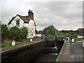
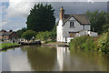
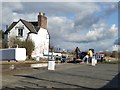
3
Lock Keeper's Cottage, Chemistry Lock, Shropshire Union Canal
Grade II listed. Listing number 1375739. Lock keeper's cottage with walled yard and privy. c1800. Painted brick with grey slate roof.
Image: © Andrew Abbott
Taken: 9 Jul 2022
0.08 miles
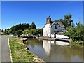
5
Chemistry Lock, Shropshire Union Canal
The Victorian lock cottage is grade II listed.
Image: © Stephen McKay
Taken: 9 Sep 2013
0.08 miles
6
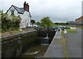
Lock keepers cottage next to Chemistry Lock No 39
Image: © Mat Fascione
Taken: 6 Jul 2019
0.08 miles
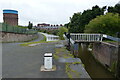
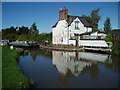
8
View from Chemistry Lock
Looking towards Boughton Water pumping station.
Image: © Andrew Abbott
Taken: 1 May 2022
0.09 miles
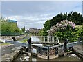
9
Negotiating Chemistry Lock
Narrowboat "Teal" navigating through Chemistry Lock on the Shropshire Union Canal
Image: © Eirian Evans
Taken: 24 Feb 2016
0.09 miles
10
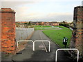
Footpath from Hoole Lane to Pentland Close, and a bench mark
This footpath provides access from Hoole Lane to a playground and the modern housing in Pentland Close. There is an Ordnance Survey bench mark on the inner face of the left hand brick pier - Image
Image: © John S Turner
Taken: 25 Nov 2011
0.10 miles