IMAGES TAKEN NEAR TO
Filkins Lane, CHESTER, CH3 5EH
Introduction
This page details the photographs taken nearby to Filkins Lane, CH3 5EH by members of the Geograph project.
The Geograph project started in 2005 with the aim of publishing, organising and preserving representative images for every square kilometre of Great Britain, Ireland and the Isle of Man.

There are currently over 7.5m images from over14,400 individuals and you can help contribute to the project by visiting https://www.geograph.org.uk
Image Map
Images are licensed for reuse under creativecommons.org/licenses/by-sa/2.0
Notes
- Clicking on the map will re-center to the selected point.
- The higher the marker number, the further away the image location is from the centre of the postcode.
Image Listing (69 Images Found)
Images are licensed for reuse under creativecommons.org/licenses/by-sa/2.0
Image
Details
Distance
1
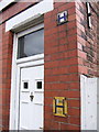
Fire Hydrant Signs
This house has two Fire Hydrant Signs, the one we are more familiar with in yellow, and an old blue and white enamel one, higher up.
(For those unfamiliar with these signs, the top figure is the diameter in millimetres of the water main supplying the hydrant, the bottom figure is the distance the hydrant is away from the sign in metres. In some places the hydrant signs remain in imperial units - inches diameter and feet away.)
Image: © BrianPritchard
Taken: 29 Jan 2008
0.03 miles
2
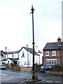
Old sewerage venting post and Boundary Stone
At the junction of Filkins Lane and Chapel Lane, stands this old sewerage venting post. It was recently restored, but I'm not sure if it still serves its original purpose.
The building on the left is now apartments, but a part of it was used as a chapel at one time, hence, Chapel Lane.
Image: © BrianPritchard
Taken: 7 Jan 2008
0.04 miles
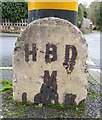
3
Boundary Stone, on an Island
This Concrete Boundary Stone can be found at the junction of Filkins Lane and Chapel Lane. I think its letters and date are, HBD
M
1983?
Image: © BrianPritchard
Taken: 7 Jan 2008
0.04 miles
4
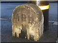
Old Boundary Marker junction of Chapel Lane and Filkins Lane, Boughton
Parish Boundary Marker by the UC road, in parish of Chester (Chester District), junction Chapel Lane and Filkins Lane, Boughton, on island against lamp post. Stone post with inset metal letters.
Inscription reads:- : H B D / M / 1913 :
Inscription refers to: Harry B Dutton, Mayor of Chester 1912/3
To be surveyed
Milestone Society National ID: CH_CHES08pb.
Image: © Milestone Society
Taken: Unknown
0.04 miles
5
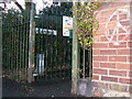
Gated pathway, with a Boundary Stone
The Boundary Stone is at the bottom right of the gate, with just a large S inscribed on it. The sign behind the gate says NO CYCLING, as this footpath leads to a children's playground.
Image: © BrianPritchard
Taken: 7 Jan 2008
0.07 miles
6
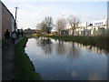
The Shroppy
A view looking to the northwest along the Shropshire Union canal just after it has passed under the A51 Tarvin Road. The water tower at the Chester Waterworks can be seen in the distance.
Image: © Phil Williams
Taken: 28 Dec 2006
0.07 miles
7
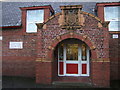
Ornate school entrance, at Cherry Grove School
The famous Chester architect John Douglas, was involved with the building of this school. The coat of arms shows three lions on one half, sheafs of wheat on the other.
Image: © BrianPritchard
Taken: 7 Jan 2008
0.07 miles
8
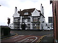
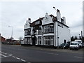
The Bridge Inn, Boughton, Chester
The Bridge Inn on Tarvin Road, Boughton, Chester. Picture taken from Filkin's Lane at the side of the Fishing Tackle Shop.
Image: © BrianPritchard
Taken: 29 Jan 2008
0.08 miles
9
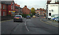
Tarvin Road (A51)
The A51 at Boughton, Chester.
Image: © David Dixon
Taken: 9 Nov 2010
0.08 miles