IMAGES TAKEN NEAR TO
Birchwood Close, CHESTER, CH2 4RU
Introduction
This page details the photographs taken nearby to Birchwood Close, CH2 4RU by members of the Geograph project.
The Geograph project started in 2005 with the aim of publishing, organising and preserving representative images for every square kilometre of Great Britain, Ireland and the Isle of Man.

There are currently over 7.5m images from over14,400 individuals and you can help contribute to the project by visiting https://www.geograph.org.uk
Image Map
Images are licensed for reuse under creativecommons.org/licenses/by-sa/2.0
Notes
- Clicking on the map will re-center to the selected point.
- The higher the marker number, the further away the image location is from the centre of the postcode.
Image Listing (15 Images Found)
Images are licensed for reuse under creativecommons.org/licenses/by-sa/2.0
Image
Details
Distance
2
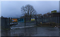
A United Utilities wastewater pumping station
Image: © Ian Greig
Taken: 15 Jan 2016
0.09 miles
3
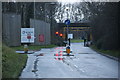
The entrance to encirc
Each week more than six million bottles of beer and cider are filled at this plant
http://www.encirc-beverages.com/product.php?Beer-Cider-Bottling-1
Image: © Ian Greig
Taken: 15 Jan 2016
0.14 miles
6
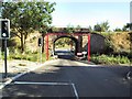
Mind Your Head!
This old stone arched bridge is the new access to the site which was Ince B power station. That was demolished to make way for a new development for glass production. The bridge was so low that large lorries could not pass, so the surface had to be lowered by several feet, and the foundations of the bridge re-inforced.Adjacent to Ince and Elton Station, at the intersection of Ash Lane and Hapsford Lane
Image: © Roger May
Taken: 2 Sep 2005
0.20 miles
7
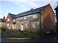
Rock Farm, Elton
The ground in front of the house is bare bedrock
Image: © John Lord
Taken: 5 Dec 2009
0.22 miles
8
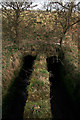
Last gasps of the River Gowy
The Gowy meanders across the Cheshire Plain eventually entering the Mersey Estuary. Here it runs beneath the railway line on the last leg of its journey
Image: © Peter Styles
Taken: 26 Mar 2010
0.22 miles
9
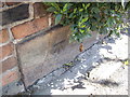
Cut Mark: Manor Farm, Ince Lane, Elton
OS Cut Mark on the roadside wall outside Manor Farm, Ince Lane, Elton. Number B11344 on the Benchmark Database, see http://www.bench-marks.org.uk/bm37723
Image: © VBForever
Taken: 24 Apr 2011
0.22 miles