IMAGES TAKEN NEAR TO
Church Lane, CHESTER, CH2 4HP
Introduction
This page details the photographs taken nearby to Church Lane, CH2 4HP by members of the Geograph project.
The Geograph project started in 2005 with the aim of publishing, organising and preserving representative images for every square kilometre of Great Britain, Ireland and the Isle of Man.

There are currently over 7.5m images from over14,400 individuals and you can help contribute to the project by visiting https://www.geograph.org.uk
Image Map
Images are licensed for reuse under creativecommons.org/licenses/by-sa/2.0
Notes
- Clicking on the map will re-center to the selected point.
- The higher the marker number, the further away the image location is from the centre of the postcode.
Image Listing (48 Images Found)
Images are licensed for reuse under creativecommons.org/licenses/by-sa/2.0
Image
Details
Distance
2
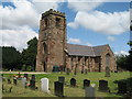
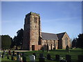
St. Lawrence Church, Stoak
St. Lawrence is an ancient parish church, originally serving the townships of Great Stanney, Little Stanney, Stoak and part of Whitby. Parish registers commence in 1573. A Saxon chapel stood originally on the site but the present church dates from 1827.
Image: © Sue Adair
Taken: 9 Jul 2009
0.03 miles
6
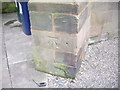
Cut Mark, St Lawrence's Church, Stoak
OS Cut Mark, St Lawrence's Church, Stoak. Number B10544 on Benchmark Database, see: http://www.bench-marks.org.uk/bm36668
Image: © VBForever
Taken: 4 Feb 2011
0.05 miles
7
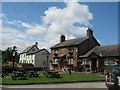
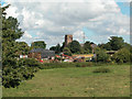
The Bunbury Arms, Stoak
The Bunbury Arms in Stoak (or Stoke) which was a township in Stoak Parish, Wirral Hundred, which became a civil parish in 1866.
Image: © Sue Adair
Taken: 9 Jul 2009
0.05 miles
8
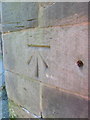
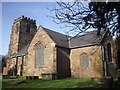
Bench mark on St Lawrence' church, Stoak
This Ordnance Survey bench mark is on the north west buttress of St Lawrence' church, Stoak. The strange hole is not associated with the bench mark. See also Image
Image: © John S Turner
Taken: 17 Jan 2019
0.05 miles
9
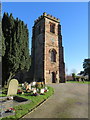
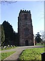
The tower of St Lawrence' church, Stoak
There is an Ordnance Survey bench mark on the north west tower buttress, nearest the camera - Image
Image: © John S Turner
Taken: 17 Jan 2019
0.05 miles
10
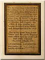
Notice in St Lawrence's Porch
Old notice in the porch of Image] records the rebuilding work carried out in 1827:
"The accommodation in this CHURCH was enlarged by the Erection of a Gallery in the year 1827, by which means 55 additional sittings were obtained, and in consequence of a grant from the SOCIETY for promoting the Enlargements & Building of Churches and Chapels, the whole of that number are hereby declared to be FREE and unappropriated for ever.
Also in the same Year, a new Tower and the north Transept were added and the south wall and south Transept were rebuilt."
Image: © David Dixon
Taken: 7 Sep 2015
0.05 miles