IMAGES TAKEN NEAR TO
Wervin Road, CHESTER, CH2 4BY
Introduction
This page details the photographs taken nearby to Wervin Road, CH2 4BY by members of the Geograph project.
The Geograph project started in 2005 with the aim of publishing, organising and preserving representative images for every square kilometre of Great Britain, Ireland and the Isle of Man.

There are currently over 7.5m images from over14,400 individuals and you can help contribute to the project by visiting https://www.geograph.org.uk
Image Map
Images are licensed for reuse under creativecommons.org/licenses/by-sa/2.0
Notes
- Clicking on the map will re-center to the selected point.
- The higher the marker number, the further away the image location is from the centre of the postcode.
Image Listing (12 Images Found)
Images are licensed for reuse under creativecommons.org/licenses/by-sa/2.0
Image
Details
Distance
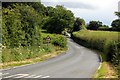
1
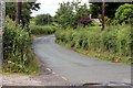
Wervin Road, Wervin
Wervin Road as it leaves the village, taken from opposite the junction with Ashwood Lane.
Image: © Jeff Buck
Taken: 30 Jun 2012
0.01 miles
2
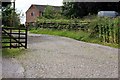
Farm Entrance, Wervin
This cobbled lane leads to Chapel House Farm and to the remains of Wervin Chapel.
Image: © Jeff Buck
Taken: 30 Jun 2012
0.02 miles
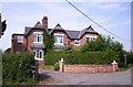
5
Wervin Road, Wervin
Wervin Road as it enters the village.
Image: © Jeff Buck
Taken: 30 Jun 2012
0.14 miles
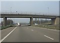
6
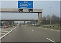
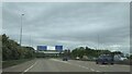
M53 for Merseyside
The "mid-Wirral motorway" strikes out for Merseyside at the M56 junction. Ashwood Lane bridge is in the background.
Image: © Peter Whatley
Taken: 23 Mar 2012
0.17 miles
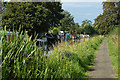
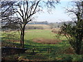
10
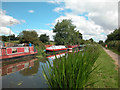
Shropshire Union Canal Moorings
Top Farm Moorings Croughton Chester
Image: © Dennis Turner
Taken: 7 Aug 2005
0.21 miles