IMAGES TAKEN NEAR TO
Sandileigh, CHESTER, CH2 3QN
Introduction
This page details the photographs taken nearby to Sandileigh, CH2 3QN by members of the Geograph project.
The Geograph project started in 2005 with the aim of publishing, organising and preserving representative images for every square kilometre of Great Britain, Ireland and the Isle of Man.

There are currently over 7.5m images from over14,400 individuals and you can help contribute to the project by visiting https://www.geograph.org.uk
Image Map
Images are licensed for reuse under creativecommons.org/licenses/by-sa/2.0
Notes
- Clicking on the map will re-center to the selected point.
- The higher the marker number, the further away the image location is from the centre of the postcode.
Image Listing (157 Images Found)
Images are licensed for reuse under creativecommons.org/licenses/by-sa/2.0
Image
Details
Distance
1

Suburban Sunset, Hoole, Chester
One of the amazing sunsets we had during late January and early February 2023.
Image: © Jeff Buck
Taken: 5 Feb 2023
0.08 miles
2
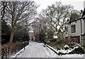
Flookersbrook, Chester
Flookersbrook stands on the line of an ancient road which stretched from the fortress at Deva to Warrington and beyond. Flookersbrook has been cut off from Hoole Road which is now the main route into Chester and retains a quiet almost village atmosphere.
Image: © Jeff Buck
Taken: 19 Jan 2013
0.09 miles
3
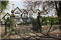
Flookersbrook Hall, Hoole, Chester
The original Flookersbrook Hall was destroyed during the siege of Chester (February 1645 to January 1646).
Image: © Jeff Buck
Taken: 30 Apr 2016
0.09 miles
4

Panel of names, on a War Memorial
This panel is on the rear of the War Memorial on Hoole Road, Chester. The picture was taken to research Lawson G. W. because a small wooden cross lay beneath, with his name written on it, with his age, at only 161/2, when he died.Image
Image: © BrianPritchard
Taken: 24 Jan 2008
0.09 miles
5
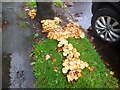
Honey Fungus (Armillaria mellea)
Honey Fungus seen in Woodlands Drive, Hoole. According to my Collins guide to Mushrooms and Toadstools the caps begin convex and later flat as seen here. They are edible but need to be cooked thoroughly to avoid tummy ache.
Image: © Jeff Buck
Taken: 6 Oct 2020
0.09 miles
6
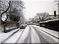
Ashby Place, Hoole, Chester
The cobbled street of Ashby Place near Flookersbrook. Flookersbrook has been cut off from Hoole Road which is now the main route into Chester and retains a quiet almost village atmosphere.
Image: © Jeff Buck
Taken: 22 Jan 2013
0.10 miles
7
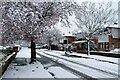
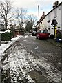
Snow in Woodlands Drive, Chester
Still snowing at 08:00 but sunny with clear blue sky by 10:00. By midday the snow had almost completely gone.
Image: © Jeff Buck
Taken: 10 Mar 2023
0.10 miles
8

So very young
While looking around the War Memorial on Hoole Road, Chester, this simple wooden cross, upset me when you see just how young this soldier was when he died.
On the War Graves Commission web site, Private Lawson G. of the Cheshire Regiment, 'D' Coy. 1st./5th. Bn. Date of death, shown as 21.9.1916, Service No. 2503. Buried at the Delville Wood Cemetery, Longueval, France
Image: © BrianPritchard
Taken: 24 Jan 2008
0.10 miles
9
Flookersbrook, Chester
Flookersbrook stands on the line of an ancient road which stretched from the fortress at Deva to Warrington and beyond. Flookersbrook has been cut off from Hoole Road which is now the main route into Chester and retains a quiet almost village atmosphere.
Image: © Jeff Buck
Taken: 21 Jan 2013
0.10 miles
10
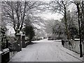
Kilmorey Park Avenue, Chester
Wikipedia http://en.wikipedia.org/wiki/Hoole
Image: © Jeff Buck
Taken: 21 Jan 2013
0.10 miles