IMAGES TAKEN NEAR TO
South Avenue, CHESTER, CH2 3PR
Introduction
This page details the photographs taken nearby to South Avenue, CH2 3PR by members of the Geograph project.
The Geograph project started in 2005 with the aim of publishing, organising and preserving representative images for every square kilometre of Great Britain, Ireland and the Isle of Man.

There are currently over 7.5m images from over14,400 individuals and you can help contribute to the project by visiting https://www.geograph.org.uk
Image Map
Images are licensed for reuse under creativecommons.org/licenses/by-sa/2.0
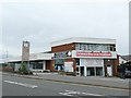
Notes
- Clicking on the map will re-center to the selected point.
- The higher the marker number, the further away the image location is from the centre of the postcode.
Image Listing (609 Images Found)
Images are licensed for reuse under creativecommons.org/licenses/by-sa/2.0
Image
Details
Distance
1
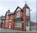
Back-street barber...
...at the junction of South Avenue and Ermine Road.
Image: © Bill Harrison
Taken: 30 Jun 2013
0.01 miles
2
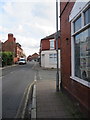
Ermine Road at its junction with West Street
Looking along Ermine Street, Hoole near its junction with West Street. There is an Ordnance Survey bench mark on the wall of the shop behind the grey lamppost - Image
Image: © John S Turner
Taken: 10 Oct 2017
0.01 miles
3
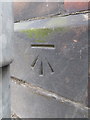
Bench mark in Ermine Road, Hoole
This Ordnance Survey bench mark is on the wall of a shop in Ermine Road, but it is hidden behind a modern lamppost. See also Image
Image: © John S Turner
Taken: 10 Oct 2017
0.01 miles
4
The Flookersbrook RIP
The pub, just off Hoole Road, is shuttered...
Image: © Bill Harrison
Taken: 30 Jun 2013
0.02 miles
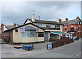
5
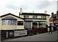
The Flookersbrook (closed), Hoole, Chester
Previously known as 'The Ermine' this pub was renamed The Flookersbrook in 2004. Rated "one of the ten worst pubs in Chester" by 'The Chester Beer Project' it has now closed along with the next door Honda dealership. The area may be due for redevelopment.
chesterwalls http://www.chesterwalls.info/gallery/ermine.html
The Chester Beer Project http://chesterbeerproject.blogspot.co.uk/
Image: © Jeff Buck
Taken: 11 Feb 2013
0.03 miles
6
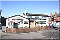
The Flookersbrook (open), Hoole, Chester
Previously known as 'The Ermine' this pub was renamed The Flookersbrook in 2004. Rated "one of the ten worst pubs in Chester" by 'The Chester Beer Project' it closed in 2013 along with the next door Honda dealership but has recently re-opened again. The area may still be due for redevelopment in the future.
Image: © Jeff Buck
Taken: 10 Feb 2016
0.03 miles
7
The Flookersbrook, Hoole Way
Best pronounced while still sober. The brook that gave its name to the pub, and the area, flows (now in culvert) under the road immediately in front of it. See also Image
Image: © Stephen Craven
Taken: 1 Jun 2019
0.03 miles
8
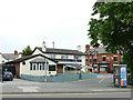
Against The Grain, Hoole, Chester
Against The Grain furniture clearance warehouse on Hoole Road, Chester is housed in a former Honda showroom. The Labour party election posters in the upstairs windows seem to indicate that the rooms above have been hired out for the United Kingdom general election 2015.
Image: © Jeff Buck
Taken: 11 May 2015
0.04 miles
9
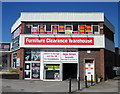
Clearance completed
This "clearance warehouse", which was still open in 2015 Image, has finally closed.
Image: © Stephen Craven
Taken: 1 Jun 2019
0.04 miles
10
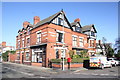
Veterinary Surgery & Dental Practice, Flookersbrook, Chester
Flookersbrook Veterinary Surgery and next door the Allandale Dental Practice at the corner of Ermine Road and Halkyn Road, Flookersbrook, Hoole, Chester.
Image: © Jeff Buck
Taken: 10 Feb 2016
0.04 miles