IMAGES TAKEN NEAR TO
Neston Drive, CHESTER, CH2 2HR
Introduction
This page details the photographs taken nearby to Neston Drive, CH2 2HR by members of the Geograph project.
The Geograph project started in 2005 with the aim of publishing, organising and preserving representative images for every square kilometre of Great Britain, Ireland and the Isle of Man.

There are currently over 7.5m images from over14,400 individuals and you can help contribute to the project by visiting https://www.geograph.org.uk
Image Map (Loading...)


Getting Data...Please wait
Leaflet Map data © OpenStreetMap
Images are licensed for reuse under creativecommons.org/licenses/by-sa/2.0
Notes
- Clicking on the map will re-center to the selected point.
- The higher the marker number, the further away the image location is from the centre of the postcode.
Image Listing (7 Images Found)
Images are licensed for reuse under creativecommons.org/licenses/by-sa/2.0
Image
Details
Distance
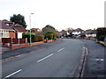
1
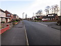
Neston Drive, Chester
Neston Drive approaching the junction with Sutton Drive on the right.
Image: © Jeff Buck
Taken: 15 Jan 2015
0.01 miles
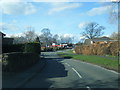
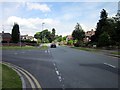
3
Junction of Wealstone Lane and Neston Drive
The junction of Wealstone Lane and Neston Drive in Upton. Chester.
Image: © Jeff Buck
Taken: 15 Jan 2015
0.12 miles
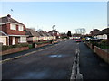
5
Ellesmere Avenue, Chester
Ellesmere Avenue heading from the junction with Dicksons Drive.
Image: © Jeff Buck
Taken: 15 Jan 2015
0.23 miles
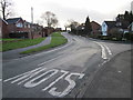
6
Junction of Wealstone Lane and Plas Newton Lane
Image: © Jeff Buck
Taken: 18 Jun 2012
0.23 miles
7
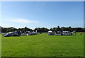
Recreation ground, Upton
On the day of Upton Fun Day.
Image: © JThomas
Taken: 14 Sep 2019
0.24 miles