IMAGES TAKEN NEAR TO
Breton Close, CHESTER, CH2 1HY
Introduction
This page details the photographs taken nearby to Breton Close, CH2 1HY by members of the Geograph project.
The Geograph project started in 2005 with the aim of publishing, organising and preserving representative images for every square kilometre of Great Britain, Ireland and the Isle of Man.

There are currently over 7.5m images from over14,400 individuals and you can help contribute to the project by visiting https://www.geograph.org.uk
Image Map
Images are licensed for reuse under creativecommons.org/licenses/by-sa/2.0
Notes
- Clicking on the map will re-center to the selected point.
- The higher the marker number, the further away the image location is from the centre of the postcode.
Image Listing (12 Images Found)
Images are licensed for reuse under creativecommons.org/licenses/by-sa/2.0
Image
Details
Distance
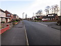
1
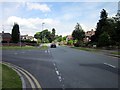
Junction of Wealstone Lane and Plas Newton Lane
Image: © Jeff Buck
Taken: 18 Jun 2012
0.09 miles
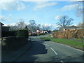
3
Junction of Wealstone Lane and Neston Drive
The junction of Wealstone Lane and Neston Drive in Upton. Chester.
Image: © Jeff Buck
Taken: 15 Jan 2015
0.11 miles
4
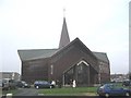
St. Columba's RC Church, Plas Newton
Taken just a few minutes after noon on a rather murky Christmas Day, this shows the congregation emerging from St. Columba's RC church, off Plas Newton Lane.
Image: © Phil Williams
Taken: 25 Dec 2005
0.14 miles
5
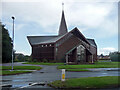
St Columba's Roman Catholic Church, Chester
St Columba's Roman Catholic Church on Plas Newton Lane, Chester. The Foundation Stone of St Columba’s was laid on 6th September 1964. Building work was completed in December the following year, and the church was officially opened on 19th February 1966 by the Bishop of
Shrewsbury.
Image: © Jeff Buck
Taken: 15 Jan 2015
0.17 miles
6
St Columba, Plas Newton Lane, Chester
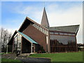
By L.A.G. Prichard, Son & Partner, 1964, and described in Pevsner as "daring, ambitious, but flimsy". What appears from the front to be an octagon is not, as the back is flat.
Image: © Stephen Richards
Taken: 19 Aug 2014
0.17 miles
7

St Columba's Roman Catholic Church, Chester
St Columba's Roman Catholic Church on Plas Newton Lane, Chester. The Foundation Stone of St Columba’s was laid on 6th September 1964. Building work was completed in December the following year, and the church was officially opened on 19th February 1966 by the Bishop of
Shrewsbury.
Image: © Jeff Buck
Taken: 15 Jan 2015
0.17 miles
8
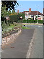
Brook Lane/Newton Lane junction
Looking towards Newton Lane from Brook Lane. There is an Ordnance Survey bench mark on the low stone wall on the left in front of 'Coniston' - Image
Image: © John S Turner
Taken: 15 Oct 2017
0.19 miles
9
Newton Lane junction from Brook Lane
Looking towards Newton Lane from Brook Lane.
Image: © John S Turner
Taken: 15 Oct 2017
0.20 miles
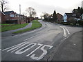
10
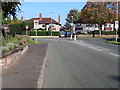
Neston Drive, Chester
Neston Drive approaching the junction with Sutton Drive on the right.
Image: © Jeff Buck
Taken: 15 Jan 2015
0.20 miles