IMAGES TAKEN NEAR TO
Wavertree Road, CHESTER, CH1 5AF
Introduction
This page details the photographs taken nearby to Wavertree Road, CH1 5AF by members of the Geograph project.
The Geograph project started in 2005 with the aim of publishing, organising and preserving representative images for every square kilometre of Great Britain, Ireland and the Isle of Man.

There are currently over 7.5m images from over14,400 individuals and you can help contribute to the project by visiting https://www.geograph.org.uk
Image Map
Images are licensed for reuse under creativecommons.org/licenses/by-sa/2.0
Notes
- Clicking on the map will re-center to the selected point.
- The higher the marker number, the further away the image location is from the centre of the postcode.
Image Listing (15 Images Found)
Images are licensed for reuse under creativecommons.org/licenses/by-sa/2.0
Image
Details
Distance
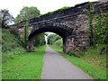
2
Bridge across the Chester Railway Path at Blacon
Image: © Mat Fascione
Taken: 14 Apr 2019
0.12 miles
3
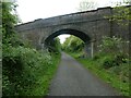
Bridge carrying track over NCN5, Chester Railway Path
Image: © David Smith
Taken: 11 May 2023
0.12 miles
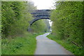
4
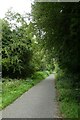
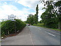
Cycle path near Blacon
Looking along part of the Chester rail path.
Image: © DS Pugh
Taken: 8 Aug 2020
0.13 miles
7
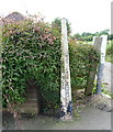
Old boundary marker on Saughall Road
Inscription reads:- CITY OF CHESTER / CHESHIRE COUNTY COUNCIL
Image: © JThomas
Taken: 15 Jun 2019
0.18 miles
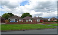
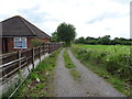
9
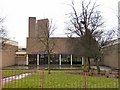
Blacon High School
Melbourne Road entrance to the High School at Blacon.
Image: © Josie Carman
Taken: 9 Mar 2006
0.20 miles