IMAGES TAKEN NEAR TO
Oulton Place, CHESTER, CH1 3EH
Introduction
This page details the photographs taken nearby to Oulton Place, CH1 3EH by members of the Geograph project.
The Geograph project started in 2005 with the aim of publishing, organising and preserving representative images for every square kilometre of Great Britain, Ireland and the Isle of Man.

There are currently over 7.5m images from over14,400 individuals and you can help contribute to the project by visiting https://www.geograph.org.uk
Image Map
Images are licensed for reuse under creativecommons.org/licenses/by-sa/2.0
Notes
- Clicking on the map will re-center to the selected point.
- The higher the marker number, the further away the image location is from the centre of the postcode.
Image Listing (1578 Images Found)
Images are licensed for reuse under creativecommons.org/licenses/by-sa/2.0
Image
Details
Distance
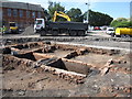
1

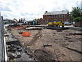
Excavating part of the George Street car park
This part of the George Street car park is to be redeveloped and, in advance of that, archaeological excavations are taking place. The area's terraced housing was demolished in the 1960s and 1970s in part to make way for the inner ring road - seen here on the right. In the foreground buildings alongside Oulton Place will be uncovered, and at the far end of the site Kinaston Street (later Kynaston St) has already been uncovered. It will be interesting to see what lies beneath these 19th century remains.
Image: © John S Turner
Taken: 6 Aug 2009
0.00 miles
2
Kinaston Street re-appears
Looking from St Martins Way, across the remains of Kinaston Street, towards the former George Street School in the distance. In the 1960s and 1970s this area was cleared, in part to make way for the inner ring road, which is behind the camera. Now the site is to be redeveloped and it is being excavated. The camera angle is looking diagonally across the cobbled street, which, according to the 1851 census, only had 7 houses on each side.
As far as I can ascertain Kinaston Street (later Kynaston Street) first appeared on the 1851 census and one of the residents was a George Kinaston (junior). George Kinaston (senior), a 'Fringe Maker', lived in the adjacent St Anne's Street and his will, dated 1857, refers to him as a 'Gentleman', and 'former fringe maker', and to his 'freehold property in St Anne Street', so as a man of substance it seems likely that the street was named by, or after, him.
Image: © John S Turner
Taken: 7 Aug 2009
0.01 miles
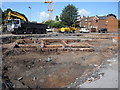
3

Excavating part of the George Street car park
This part of the George Street car park is to be redeveloped and, in advance of that, archaeological excavations are taking place. The area's terraced housing was demolished in the 1960s and 1970s in part to make way for the inner ring road - seen here on the right. As the housing was demolished in the fairly recent past heavy machinery is being used to clear the top soil and rubble down to the foundation level of the remains. In the foreground buildings alongside Oulton Place are starting to be uncovered, and at the far end of the site Kinaston Street (later Kynaston St) has already been uncovered. It will be interesting to see what lies beneath these 19th century remains.
Image: © John S Turner
Taken: 7 Aug 2009
0.01 miles
4

Excavating part of the George Street car park
This part of the George Street car park is to be redeveloped and, in advance of that, archaeological excavations are taking place. The area's terraced housing was demolished in the 1960s and 1970s in part to make way for the inner ring road - seen here beyond the excavations. This view is across the line of Kinaston Street (later Kynaston St) which has already been uncovered - the cobbled surface of the street is to the left of the photo and the excavators on the right are working on the remains of the houses. It will be interesting to see what lies beneath these 19th century remains.
As far as I can ascertain Kinaston Street first appeared on the 1851 census and one of the residents was a George Kinaston (junior). George Kinaston (senior), a 'Fringe Maker', lived in the adjacent St Anne's Street. I don't know if that family had any involvement in the development or naming of the street, but it seems possible.
Image: © John S Turner
Taken: 7 Aug 2009
0.01 miles
5
Kinaston Street re-appears
Looking from St Martins Way across the remains of Kinaston Street. In the 1960s and 1970s this area was cleared, in part to make way for the inner ring road, which is behind the camera. Now the site is to be redeveloped and it is being excavated. The camera angle is looking diagonally across the cobbled street, which, according to the 1851 census, only had 7 houses on each side. Notably the street is cobbled, unlike the nearby Oulton Place, which has the more even stone sets.
As far as I can ascertain Kinaston Street (later Kynaston Street) first appeared on the 1851 census and one of the residents was a George Kinaston (junior). George Kinaston (senior), a 'Fringe Maker', lived in the adjacent St Anne's Street. I don't know if that family had any involvement in the development or naming of the street, but it seems possible.
Image: © John S Turner
Taken: 6 Aug 2009
0.01 miles
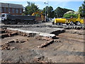
6
House outlines in Kinaston Street
Looking from St Martins Way across the remains of Kinaston Street. In the 1960s and 1970s this area was cleared, in part to make way for the inner ring road, which is behind the camera. Now the site is to be redeveloped and it is being excavated. The camera angle is looking diagonally across the cobbled street, which, according to the 1851 census, only had 7 houses on each side. I assume that each square is one house, and they don't look very big.
As far as I can ascertain Kinaston Street (later Kynaston Street) first appeared on the 1851 census and one of the residents was a George Kinaston (junior). George Kinaston (senior), a 'Fringe Maker', lived in the adjacent St Anne's Street. I don't know if that family had any involvement in the development or naming of the street, but it seems possible.
Although these houses would be considered very poor accommodation by today's standards, they were occupied in 1851 by a seemingly respectable group of people including a Brewer, a Gentleman's Servant, 3 Police Constables, a Tailor, a Lay Vicar at the Cathedral, a Coach Body Maker, and a Confectioner who was George Kinaston.
Image: © John S Turner
Taken: 6 Aug 2009
0.01 miles
7
House outlines in Kinaston Street
Looking from St Martins Way across the remains of Kinaston Street. In the 1960s and 1970s this area was cleared, in part to make way for the inner ring road, which is behind the camera. Now the site is to be redeveloped and it is being excavated. The camera angle is looking diagonally across the cobbled street, which, according to the 1851 census, only had 7 houses on each side. I assume that each square is one house, and they don't look very big.
As far as I can ascertain Kinaston Street (later Kynaston Street) first appeared on the 1851 census and one of the residents was a George Kinaston (junior). George Kinaston (senior), a 'Fringe Maker', lived in the adjacent St Anne's Street and his will, dated 1857, refers to him as a 'Gentleman', and 'former fringe maker', and to his 'freehold property in St Anne Street', so as a man of substance it seems likely that the street was named by, or after, him.
Although these houses would be considered very poor accommodation by today's standards, they were occupied in 1851 by a seemingly respectable group of people including a Brewer, a Gentleman's Servant, 3 Police Constables, a Tailor, a Lay Vicar at the Cathedral, a Coach Body Maker, and a Confectioner who was George Kinaston (junior).
The extant houses on the right are St Anne's Street, which was cut through when the inner ring road was built. The cobbled cul de sac of Kinaston Street exited onto St Anne's Street before the ring road was built.
Image: © John S Turner
Taken: 6 Aug 2009
0.01 miles
8

Excavating part of the George Street car park
This part of the George Street car park is to be redeveloped and, in advance of that, archaeological excavations are taking place. The area's terraced housing was demolished in the 1960s and 1970s in part to make way for the inner ring road - behind the camera. As the housing was demolished in the fairly recent past heavy machinery is being used to clear the top soil and rubble down to the foundation level of the known remains. In the foreground buildings close to Oulton Place are starting to be uncovered, and in the distance the former George Street School can be seen. Oulton Place linked George Street and St Anne's Street, but as the two streets were on a different alignment Oulton Place changed direction part way along. I'm not sure whether these remains are part of Oulton Place or buildings within a yard off St Anne's Street. It will be interesting to see what lies beneath these 19th century remains.
Image: © John S Turner
Taken: 7 Aug 2009
0.01 miles