IMAGES TAKEN NEAR TO
Rhyd Y Gwern Lane, CAERPHILLY, CF83 8UH
Introduction
This page details the photographs taken nearby to Rhyd Y Gwern Lane, CF83 8UH by members of the Geograph project.
The Geograph project started in 2005 with the aim of publishing, organising and preserving representative images for every square kilometre of Great Britain, Ireland and the Isle of Man.

There are currently over 7.5m images from over14,400 individuals and you can help contribute to the project by visiting https://www.geograph.org.uk
Image Map
Images are licensed for reuse under creativecommons.org/licenses/by-sa/2.0
Notes
- Clicking on the map will re-center to the selected point.
- The higher the marker number, the further away the image location is from the centre of the postcode.
Image Listing (30 Images Found)
Images are licensed for reuse under creativecommons.org/licenses/by-sa/2.0
Image
Details
Distance
1
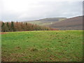
Field next to the forest
On the skyline are colliery spoil heaps above Machen
Image: © John Thorn
Taken: 15 Feb 2007
0.13 miles
2
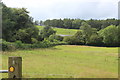
Fields either side of Rhyd-y-Gwern Lane
The hedgerow on the left is on the nearside of the lane; the roof of the building (centre) is at Fferm Pont Carreg on the far side of the lane. The woodland on the skyline is part of Coed Cefn-pwll-du.
Image: © M J Roscoe
Taken: 17 Aug 2019
0.16 miles
3
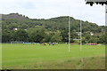
Saturday afternoon football
Chatham Recreation Ground.
Image: © M J Roscoe
Taken: 17 Aug 2019
0.16 miles
4
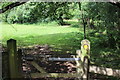
Field footpath
Public footpath along edge of field.
Image: © M J Roscoe
Taken: 17 Aug 2019
0.19 miles
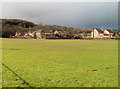
5
Min yr Afon houses viewed across rugby pitch, Machen
The view from the northern edge of a recreation ground towards houses built c1995, on a street named Min yr Afon.
Image: © Jaggery
Taken: 14 Feb 2011
0.20 miles
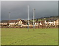
6
Diagonal view across rugby pitch, Chatham, Machen
A view from corner to corner across a rugby pitch in a recreation ground on the south side of the Rhymney River and A468 in Chatham, Machen. In the distance are houses on Bovil View.
Image: © Jaggery
Taken: 14 Feb 2011
0.20 miles
7
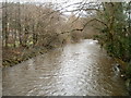
Rhymney River downstream from Forge Bridge, Machen
The Rhymney flows away from the road bridge carrying Forge Road across the river.
Image: © Jaggery
Taken: 26 Feb 2011
0.21 miles
8
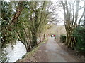
Walking along the south bank of the Rhymney, Machen
Viewed from the Forge Road and Forge Bridge end of an unnamed riverside lane.
Image: © Jaggery
Taken: 26 Feb 2011
0.21 miles
9
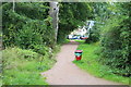
Riverside path, Machen
Path on south bank of River Rhymney (out of shot, left).
Image: © M J Roscoe
Taken: 17 Aug 2019
0.23 miles
10
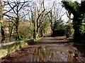
Large puddle on a Machen lane
Viewed on March 14th 2019. The lane is on the south bank of the Rhymney River.
Image: © Jaggery
Taken: 14 Mar 2019
0.23 miles