IMAGES TAKEN NEAR TO
Dranllwyn Lane, CAERPHILLY, CF83 8QS
Introduction
This page details the photographs taken nearby to Dranllwyn Lane, CF83 8QS by members of the Geograph project.
The Geograph project started in 2005 with the aim of publishing, organising and preserving representative images for every square kilometre of Great Britain, Ireland and the Isle of Man.

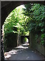
There are currently over 7.5m images from over14,400 individuals and you can help contribute to the project by visiting https://www.geograph.org.uk
Image Map
Images are licensed for reuse under creativecommons.org/licenses/by-sa/2.0
Notes
- Clicking on the map will re-center to the selected point.
- The higher the marker number, the further away the image location is from the centre of the postcode.
Image Listing (181 Images Found)
Images are licensed for reuse under creativecommons.org/licenses/by-sa/2.0
Image
Details
Distance
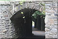
1
Former railway bridges near Machen
Two are complete, the middle one lacks its deck.
Image: © Gareth James
Taken: 30 May 2010
0.02 miles
2
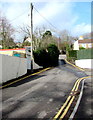
No parking in Dranllwyn Lane, Machen
Double yellow lines on both sides of Dranllwyn Lane indicate no parking at any time.
Image: © Jaggery
Taken: 14 Mar 2019
0.03 miles
3
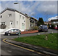
Llyswen, Machen
The cul-de-sac Llyswen ascends from Dranllwyn Lane.
Image: © Jaggery
Taken: 14 Mar 2019
0.04 miles
4
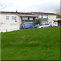
Bone Dry van in Llyswen, Machen
Text on the side of the van shows that Bone Dry is a plastering and plumbing maintenance business.
Image: © Jaggery
Taken: 14 Mar 2019
0.04 miles
5
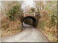
Former railway bridge, Dranllwyn Lane, Machen
Located a few metres north of the junction of Dranllwyn Lane and Dranllwyn Close.
The bridge has a headroom of only 7' 3" (2.2 metres). The road is single track.
Formerly, there were three adjacent bridges here. The middle one has been dismantled, but the one on the far side survives. http://www.geograph.org.uk/photo/2763126
Image: © Jaggery
Taken: 26 Feb 2011
0.04 miles
6
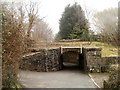
Former railway bridge, Ty Canol Lane, Machen
The low bridge is at the SE end of Ty Canol Lane. At the right edge of the view is the turning for National Cycle Network route 4. http://www.geograph.org.uk/photo/2763102
No headroom is specified for the bridge. My guess is that the reason for the absence of a sign is that the road behind the camera is a dead end, so vehicles travelling in this direction would have previously passed under the second bridge on the far side, where the headroom is 7" 3' (2.2m). http://www.geograph.org.uk/photo/2763071
Image: © Jaggery
Taken: 26 Feb 2011
0.04 miles
7
Former railway bridge, end of Dranllwyn Lane
Southernmost of two bridges Image at southern end of Ty-Canol Lane.
Image: © M J Roscoe
Taken: 31 Aug 2020
0.04 miles
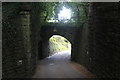
8

The two bridges
The lane which ascends the ridge north-west of Machen negotiates these low railway bridges. See Image for the opposite view.
Looking downhill towards Machen.
Image: © Jonathan Billinger
Taken: 11 Nov 2008
0.05 miles
9
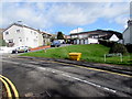
Dranllwyn Lane grit/salt box, Machen
The yellow box is near the street name sign showing that Dranllwyn Lane leads to Ty Canol Lane.
Image: © Jaggery
Taken: 14 Mar 2019
0.05 miles
10
Former railway bridges, Ty-Canol Lane
Bridges at southern end of Lane, to west of former Machen railway junction. Part of the second bridge Image is just visible.
Image: © M J Roscoe
Taken: 31 Aug 2020
0.05 miles